We should have returned to our normal viewing by now, after the great Googlemapsmania post, but we haven’t. This post isn’t a standard one either. Google have just today released an amazing new addition to their maps, 360 degree virtual tours through major US cities, with a lot more to come. Check it out here.
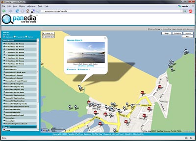
Today I’ve also released a demo of my own using Google Maps & Virtual Tours. (Shown Above) It’s a small technology demo using very high quality Virtual Tours, that are not shot on roads. You can check it out here. Have a little fun getting to know Noosa and let me know what you think. (But remember it’s only a basic demo, and none of the hotels or restaurants are real)
G’day Dean,
I’ll try and dig up those files I used for the template calibration for you. To answer your question though, I am very happy with the 360P. It’s not perfect, but it’s very, very good. Most of the time when I have stitching errors it’s a result of tripod movement, which happens a lot more than you’d think.
OK, I just found the original calibration files (they were still on my local copy of the website) so I’m uploading them to the same place now for you to play with. I no longer use this template though, as my D200 went in for repair a while ago and had the sensor replaced…. so new calibration etc.
Let me know how you get on.
Aaron.
Upsss, not 6month ago, 24 month ago,
I found your post on 360P about, -11 degree slot cut into 360P head to give you smaller nadir without shooting down.
The sample jpg are not there any more (post 6 month ago)
http://www.pano.com.au/vr/Aaron_Spence(D200 10.5_7shots).zip
I found ptgui template file on
http://www.360precision.com/360/stu/template.pts
Do you still have that example files and your experince 6 month after using template
Thanks,
Dean,
my test google map website
http://vthawaii.com/arounder/map.php
You did a good job. Can’t wait to see it finished.
G’day Thomas, Unfortunately this isn’t done with a standard set of tools. It’s all custom programmed from scratch. At present it’s only a simple demo, so adding VR’s etc is a bit of a slow process manually editing an .xml file that contains all the data for the page.
I haven’t played much with googles new My Maps yet, but I imagine they’ll be combining that function with pano import soon which would be cool. If they don’t get around to it, I hope to be able to do this sort of stuff in an automated way later in the year. I’ll keep you posted.
Thanks, Aaron.
That’s interesting Aaron. How much time and which tools are needed to compile a map like this?
Just ordered a Wintec WBT-201 GPS data logger to feed the coordinates to jpg files.