Panoramas
experience the world through beautiful panoramic photography
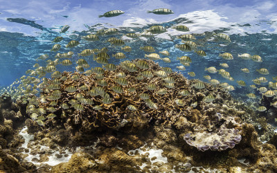
Jeju Island
These are the waters around Jeju Island which is the largest island off the Korean Peninsula. It has a dormant volcano in the centre of the island which is the tallest mountain in South Korea. Although it only has a population of 614,550 (2014) It holds the title of the worlds busiest air route from Jeju to Seoul with 10,156,000 passengers flying between the cities in 2012. These images were taken by Christophe Bailhache from The Ocean Agency and use technology developed by Panedia for the XL Catlin Seaview Survey.
Palmyra Atoll
There can be few places on earth more remote than Palmyra Atoll. In the middle of the Pacific Ocean, the nearest continent is almost 5,400 km (3,400 miles) to the north-east. Despite its isolation it has not been without drama, having had pirate treasure buried on it in 1816 and a bizarre murder in 1974. It has no permanent population nor has there been in its history. This did not not stop Commander Nichols of HMS Cormorant claiming it for the UK in 1889. He was unaware of a prior claim made by Hawaii. Today Palmyra is administered as a National Wildlife Refuge by the USA. These images were taken by Christophe Bailhache from The Ocean Agency and use technology developed by Panedia for the XL Catlin Seaview Survey.
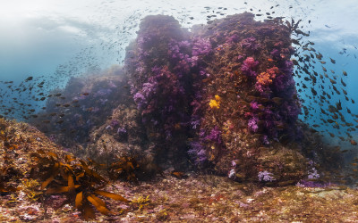
Forgotten Oceans
This panorama is from the Calabas Reef in the Atlantic section of the Global Reef Record. Most of the work I do at Panedia is aimed at helping The Ocean Agency raise awareness of what is happening beneath the waves. One of the challenges is the seas are easily forgotten, People generally don’t spend much time down there. It is out of sight, so weeks, months and years can go by without considering the impact modern life has on them.

National Museum of Australia
This beautiful pano from the National Museum of Australia sprout my curiosity about this odd shape building. The Museum was designed by architect Howard Raggatt shaped like a knot with ropes extending from the centre building, symbol of Australia story: ‘…not one but many Australians’ stories tangled together’. Another interesting feature are the exterior panels written in braille with typical Australian expressions and words of reconciliation. Personally I think this image is amazing in showing the strong colors and textures on this building.
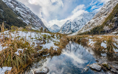
Hollyford River / Whakatipu Kā Tuka
At Panedia we will be sharing a bit of our imagery with you all. Images that are somehow special to us for this or that reason. I know that Aaron Spence shot this panorama in a glorious morning after a snow fall evening. He was simply amazed with the scenery and we all can see why… This region is part of New Zealand’s Fiordland in the South Island and this river is partially a ‘natural divider’ between the Southland and Otago regions. Following along the river is magnificent Hollyford Valley full of snow white peaks and rocky river beds. Enjoy a bit of ‘icy’ cool views while we are trying to cope with the winter heat wave (at least here in Oz). Google Maps

SS Maheno (wreck)
Love this Panedia picture taken by Aaron Spence. It is from Maheno wreck in Fraser Island. Apparently a popular tourist attraction but also a symbol of this area shallow waters. SS Maheno was an ocean liner from a New Zealand company that frequently crossed between Australia and New Zealand from 1905 to 1935. During World War I was used as a hospital ship carrying casualties from the Gallipoli campaign and other battles to, after the war, resume its regular commercial service. On the 7th July 1935, SS Maheno was hit by a severe cyclone while being towed by another ship. The towline connecting both ships parted and Maheno drifted to anchor on Fraser Island. Most of the crew manage swim onshore but eight men were never found. All attempts to re-float the ship failed and a wreck sale never found any buyers, so here it lays on its final purpose as tourism attraction. Google Maps

Brooklyn Bridge
What a better way to see New York than from Brooklyn Bridge. This panorama taken by Aaron Spence from the bridge at sunset says it all. The New York skyline under an intense orange to pink sunset, the distinctive towers shape and intricate cable patterns. From there you can ‘walk over’ the East River spotting the Statue of Liberty on one side and New York Bridge on the other. Google Maps

Jenolan Caves
These amazing limestone caves, west of the Blue Mountains are part of UNESCO World Heritage. Considered the world’s oldest known open cave system (aprox. 340 million years) the cave system counts with more than 40 km of passages, still being explored. For now, 11 caves are open to visitors to enjoy the magnificent limestone formations of astonishing beauty. I invite you to see this panorama of one of the 11 caves and to be amazed by nature’s work. Please look up and down. Jenolan Caves

Brooklyn, New York
When you are in New York, immediately you feel the rush… all is turning too fast: people walk fast, everybody seems too busy and even lunch is eaten fast or while you’re walking. Only the cars, are moving slowly…but that’s due to too much traffic. And that works for both day and night time, simply the sun is not there anymore. Crossing Brooklyn bridge is a must and doing it by sunset, a privilege. Once you cross the East River, you’re at Brooklyn and you move to a different rhythm. Somehow between Brooklyn and Manhattan bridges time slowed down for a bit. You can still see the city lights and sounds at a distance and you know all the swirl is there but here you can enjoy the views, the peaceful moments and beautiful colors, just before you dive back in, joining the fast pace of ‘The city that never sleeps’.

Qantas Founder Museum, Longreach
While filming VR content for Visit Queensland, Australia last year we were fortunate to spend some time with the wonderful Tony Martin, CEO at Qantas Founders Museum, Longreach, Queensland. Tony showed us around the Museum, and took us out to the Qantas airplanes, even doing a sunset shot from the wing of the 747. Here we’re up nice and close next to the gorgeous DC-3, while the Boeing 747 towers in the background. If you would like to see this in more detail check out our website for a VERY high rez file… you can see the rivets of the DC-3. Qantas Founder Museum, Longreach

Horseshoe Bend , Arizona
A few years ago while we were in the US we drove around the West country, through Nevada, Arizona and Utah regions. Amazing landscape all around. The area were this panorama was shot, just between Utah and Arizona is specially rich in natural beauty. Horseshoe Bend is right half way between Marble Canyon and Antelope Island, following Colorado river. In this particular spot the river ‘bends’ 180 degrees craving and shaping the landscape. This is normally a very popular location but on that day strong winds were blowing and, perhaps for that reason, no one was around. We had to walk about 30 minutes and it was certainly worthwhile. The weather was not perfect and not the best time of the day to shoot, but the view was astonishing. Up there we could understand the magnitude of that place and nature’s thin equilibrium. The strong winds quickly became a sand storm and although from the image you could not tell, it was increasingly difficult just to be there. We did the way back to the car with sand blowing at us and getting into everywhere. In the end it was definitely rewarding to be able to see Colorado river and US West territory from that perspective. Enjoy the interactive image >> https://goo.gl/K15P16
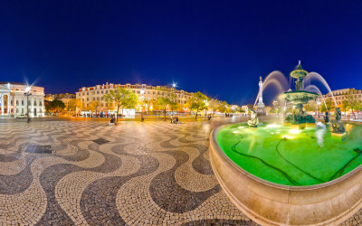
Lisbon – Rossio Square
Rossio Square, in Lisbon, is one of Portugal most visited and popular squares. Since 13th century it became place where the population would gather, when the city grew and the need to stay inside defense walls decreased. From that time it was commonly used for public ceremonies, markets, or just as a congregation place. In 1755, after a strong earthquake and tsunami this place was destroyed along with most downtown. In the following years a large city reconstruction plan was carefully undertaken and the square was rebuilt in a more organized and linear shape, that was fairly kept until today. This magnificent square with its traditional Portuguese mosaic pavement, still keeps the same use from 700 years ago. It has been the place of executions, celebrations, revolts, promenade or tourism and even the Portuguese Revolution but, it is mainly as ‘Rossio’ word states, a public common ground for people to meet. Enjoy the interactive image >> https://goo.gl/aipxkC

Pima Air & Space Museum
Located in Tucson, Arizona, in The United States of America, the Pima Air & Space Museum is one of the world’s largest non-government funded aerospace museums. The museum features a display of nearly 300 aircraft spread out over 80 acres (320,000 m²) on a campus occupying 127 acres (610,000 m²). The museum displays some of the most beautiful aircraft from all times and you can be walk around the planes and see the industry’s technological evolution.

Surfers Paradise Festival
The Surfers Paradise Festival is a colorful annual fest that involves all the local population with lots of food, arts, music and entertainment events and culminates in a big light parade and an amazing fireworks show. The tour is also available in Google Streetview, and can be seen here in Google Street View.
Eiffel Tower on Google Views
Paris has this special atmosphere, and the Eiffel Tower is right in center of it… everything just seems to flow there. Also the constellation now published on Google Views goes around this popular monument, hoping to share a bit of the City of Lights air with the rest of the world. Panedia Google Street View
Times Square, NYC on Google Views
We published another set of panoramas on the NYC theme. This time is the heart of Manhattan: Times Square. This nine panos constellation shares a bit of the light and color you can experience on that famous square. Panedia Google Street View
High Line, NYC
Once there was an old unused elevated rail line right in center New York. Then it came the idea of turning that rail line into a park and it ‘runs’ now beautifully in between city buildings, green ways and art installations. We have shared publicly on Google Views a 16 panorama collection of this unusual and amazing park. Panedia Google Street View
Albuquerque Balloon Fiesta
Having the privilege of watching this fantastic and colorful balloon festival and be able to produce nice panoramas seems pointless if you don’t share it with anyone. So it makes every sense to publish it on Google views so that people can have a glance of how beautiful it is. Here it is our constellation with 29 panoramas of Glowdeo Balloons of all different shapes, sizes and crazy characters. Panedia Google Street View
Uluru Constellation on Google Views
Uluru is not a very accessible site for tourists. Visiting that place right in the center of Australia is possible but not always easy, considering the wide distances, the weather conditions and even some religion related restrictions. Sharing this Uluru virtual tour on Google views, making it available from everywhere else, is allowing people who can’t or will never make the travel here, to see this amazing place. Panedia Google Maps.
Sydney Opera House on Google Views
Panedia just uploaded a 14 panorama constellation of the Sydney Opera House during the Sydney Vivid Festival. These are some impressive, colorful panos featuring both Sydney Opera House and Sydney Bridge, the two most iconic buildings in Sydney. Panedia Google Street View

Bermuda – Turks & Caicos
Still in Bermuda, our Catlin Seaview Survey partners were capturing images of the beautiful and rich diversity of species that live around the coral in this area. Google Street View

Bermuda – Mary Celestia Wreck
Our Catlin Seaview Survey partners were in Bermuda leading up to the launch of the Catlin Global Reef Record on September 23rd. They shot a number of areas for us to produce virtual tours of. Probably the most interesting is the ship wreck of the Mary Celestia. The Mary Celestia was a paddle steamer which sunk in 1864, it was being used to smuggle ammunitions and other supplies to the Confederate forces during the American Civil War. The wreck sits in only 55 feet of water and one of the huge paddle wheels in clearly visible at the dive site. The tour was also uploaded to Google Streetview, and can be seen here in Google Oceans.

Whale Sharks – Underwater Virtual Tour
I was very excited when the team shot WHALE SHARKS for the first time recenlty. I’ve been asking for something big… I was expecting whales… but instead I got WHALE SHARKS. We also produced some coral panoramas from Gloves Reef in Belize. But did I mentioned… Whale Sharks 😉

Lady Elliot Island – Manta Ray Virtual Tour
I was with the Catlin Seaview Survey team on Lady Elliot Island recently for a National Geographic documentary series on Australian Coastlines. They wanted to do a segment on the Catlin Seaview Survey, so we all had to suit up and perform our roles for the cameras. Of course we always take the opportunity to shoot great content when it presents. Enjoy the stunning Manta Rays, sitting like space voyaging battleships above the coral planets. By the way, I highly recommend Lady Elliot Island. It’s a beautiful low key place, where coral reefs live just a few meters off the beach. Not only that but the flight in and out is by small aircraft, a great experience on its own.

Galapagos Sea Lions
The Galapagos National Park is a mecca for nature lovers with amazing biodiversity to be found both above and below the water. Together with Google, we worked with locally based scientific and conservation groups The Charles Darwin Foundation and the Galapagos National Park Service in the area. Of course our primary area of interest is what lives beneath the water, the Sea Lions being a very playful highlight for all involved. This is one of the best underwater panoramas we’ve ever produced, the series it’s from is also one of the most difficult. 10+ Sealions darting all over the place at lightning speed… you can bet there was more than the odd flipper that needed some post production love.

Antilla Wreck – Aruba
Underwater Ship Wrecks are fascinating to view, and often encompass equally fascinating stories. The Antilla was another casualty of World War II, when hostilities broke out between Germany and the Netherlands. Here’s Wikipedia’s take on the events that lead to her 1939 sinking: On 9 April Germany invaded Denmark and Norway. This increased the fear that the Netherlands would also be invaded, so on 12 April Dutch authorities in Aruba confined Antilla’s crew to their ship. On 10 May Germany invaded the Netherlands so the Dutch government ordered the seizure of all German ships in the Dutch Antilles. At 0310 hrs on 10 May a section of Dutch Marines in two boats approached Antilla to board her but Schmidt refused to lower the gangway. The Dutch marines were commanded by a Captain who anticipated armed resistance from the German crew. He therefore postponed the boarding to first light, when a machine gun positioned ashore could provide cover. The German crew used the delay to start scuttling Antilla. One crewman locked himself in the engine room, opened her seacocks and climbed out through the funnel. Other crew set fire to several parts of the ship. At 0500 hrs the Dutch marines boarded the ship and at 0530 the German crew was assembled on the poop deck. The Marines escorted the crew ashore in a lifeboat and handed them into the custody of the Royal Marechaussee. At 0600 hrs two Netherlands Coastguard vessels, HM Aruba and HM Practico, reached Malmok Bay and found Antilla on fire. Two of Aruba’s crew boarded Antilla, found the engine room and numbers 4 and 5 holds afire, and that it was not possible to reach the seacocks and close them. After the Dutch marines had removed the German crew, Aruba fired two rounds at Antilla from her 37mm gun. By 0650 hrs Antilla was afire from stem to stern and listing 20 degrees to port. Aruba left Malmok Bay at 1130 hrs, by which time Antilla’s list had increased to 30 degrees and she was sinking.

Central Park, New York
Central Park is literately the lung of New York. In one of the biggest, more populated and busiest world’s capital this big park is a place where you can ‘feel out of the big apple’. Here you can find quiet, peace and contact with nature and all just in the center of New York. It is amazing how you can be there without spotting huge buildings or listening to the traffic noise.

Perth Virtual Tour
I was in Perth recently shooting virtual tours of hotels for the Ascott Group. Of course when I wasn’t shooting inside, I was out shooting Perth Virtual Tours. Around the city and out to Fremantle. It was a quick but enjoyable trip, I hope to get back sometime in the not too distant future.

DJP – First Gallery Showing
Darren Paine one of my oldest friends, a good buddy from primary school, recently had his first photographic gallery showing. He’s a wedding and portrait photographer, so he showcased his portraits. The showing coincided with the year of his 40th birthday… so he managed to tick an item off his bucket list… gallery showing by 40. Of course I had to shoot an Art Gallery Virtual Tour to immortalise the event. Well done old mate.

Palmela Castle
Castelo de Palmela is one of Portugal many castles. It is located on the top of the beautiful little village of Palmela and its origins go so far has 8th century. Although more than 1200 years old it has a quite well maintained structure and is classified National Monument since 1910. Adjacent to the castle there is an old church and a convent dated from around 1400. The convent is now a very nice and cozy hotel where this pictures were taken.

Eiffel Tower
The Eiffel Tower is an iron lattice tower located on the Champ de Mars in Paris. It was named after the engineer Gustave Eiffel, whose company designed and built the tower. For a long time it was the tallest building in the world and although it was surpassed it still holds the its famous iconic design. From the top you can have a fantastic view and a real feel of the ‘Pariseinne’ romantic atmosphere.

Uluru (Ayers Rock) Virtual Tour – Outback
Uluru, formerly known as Ayers Rock, is a place of immense beauty with a definite spiritual aspect. It’s the worlds largest monolith (single big rock), being located in the middle of outback Australia, it towers over the flat surrounding desert. Official Uluru National Park – Link At present you can still climb Uluru, although the owners ask that you don’t. The climb is located on the western face, it’s extremely steep, with chains to help climb portions of it. The climb closes at 8am on any day the temperature is forecast to top 36°C (97°F) I shot the climb from the ground but am not allowed to show it. I chose to respect the wishes of the owners and not climb. Instead I did the 10km (6.2 miles) walk around the base of Uluru. The base walk is amazing. Even if you choose to climb Uluru, make time to walk the base as well. IMO the best way to walk the base is to start at the south car park before dawn, then walk east, counter clockwise around the rock. This way you walk towards the sun as it breaks the horizon… a sunning sight. As the sun gets a little higher & hotter you turn the eastern edge of Uluru and put your back to the sun walking west along the northern rock face. On this section I was going against the flow of hordes of tourists trying to shield their faces & eyes from the intense sun beating down. I shot virtual tours all around Uluru, unfortunately I’m prevented from showing any virtual tours of the northern & north western sides of Uluru. The north face is VERY different from the southern views. It’s heavily pock marked with gashes and rock falls. Looks a little like a person someone has taken a knife too, cutting gashes, and removing skin to reveal organs and brain. Not pretty, but fascinating nonetheless. Uluru map containing virtual tours. Uluru (Ayers Rock) Map with all virtual tours – Link

Sydney Rock Pools – Virtual Tour
Over a couple of stunning winters days in Sydney last year I shot more than 170 virtual tours from Palm beach in the far north of Sydney to Maroubra beach in the south. In the process I visited a LOT of amazing Sydney Rock Pools, which are featured here for your viewing pleasure. [Note: Rock Pools are also known as Sea Baths & Ocean Pools] I’ve covered less than 1/2 of the Rock Pools in Sydney, next time I’m there I plan to shoot many more, eventually having virtual tours of every Rock Pool. If you’re in Sydney with a car, a fantastic day can be had driving all the way to the top of the Sydney coastline at Palm Beach / Barrenjoey Headland, then heading south, stopping at every beach and rocky headland you come across. The Sydney coastline is diverse and beautiful, along with its inhabitants and structures. Ocean Pools History – External Link North Narrabeen Rock Pool Sydney Rock Pools map with virtual tours.Sydney Rock Pools Map – FullScreen Link

Kings Canyon Virtual Tour – Outback Australia
Kings Canyon (Watarrka) National Park is a stunning place, 4hrs drive from Alice Springs in the middle of Outback Australia. It also happens to be 4hrs drive from Uluru (Ayers Rock) You can include it as part of a loop, driving west along the Macdonnell ranges from Alice Springs on Larapinta Drive, then heading to Uluru from Kings Canyon, which is what I did. (4wd recommended) There are 2 main walks at Kings Canyon, a short walk along the valley floor at the foot of the canyon walls. It’s about 500m (1600ft) and takes 30mins at a leisurely pace. Near the end is a beautiful rock pool, depending on the season/rain. The 2nd walk is a much more serious affair of 5.5km (3.5miles) which takes around 3.5hrs to complete. Seeing as this is in outback Australia, which is a HOT place, it’s best to start this walk very early in the morning… or perhaps later in the day. The walk beings with a killer uphill slog, known as heartbreak hill. By the time you reach the top your legs are jelly & your heart pounding. Interestingly this used to be the end of the walk, but lots of people injured themselves coming down the steep hill after walking for 3+hrs. So the park rangers reversed the track to make the hill the start & now have virtually zero injuries. After spending 4hrs shooting virtual tours on the track, my legs really were jelly coming down the gentle slope on the other side of the canyon, I was VERY glad to not be coming down heartbreak hill.

Kakadu Virtual Tours – Anbangbang Rock Art
Earlier this year I was in Darwin shooting for the Northern Territory Library. I organised for one extra day in my schedule to allow me to zoom out to Kakadu & shoot some virtual tours. It’s a 3hr+ drive each way from Darwin to Jabiru in the Kakadu NP, so I didn’t expect to have much time for shooting. Plus the wet season wasn’t over yet, so most places were inaccessible. Even so the couple of places I could get to were amazing. Official Kakadu National Park Link The Nourlangie and Nanguluwur art sites are a short drive from the Kakadu visitors centre and about a 1.5km (1 mile) walk. The art & rock shelters are amazing to see, and very worthwhile.

Port Arthur Virtual Tours – Tasmania
Quite some time ago I was in Tasmania shooting hundreds of virtual tours. One morning while staying in Hobart (capital city) I got up at 4am to drive out to Port Arthur (1.5hrs away) to shoot virtual tours at sunrise. Driving 1.5hrs for a sunrise shoot is always a little risky. It’s still dark when you leave, so all you have to go on are the weather reports from the night before & what clouds you can see locally in the dark. Fortunately this morning was beautiful. The Port Arthur ruins are some of the oldest in Australia and sit on a beautiful waterway. If it wasn’t for the cruel & severe life convicts endured here… I’m sure it would have been quite lovely. Port Arthur Ruins at Sunrise Port Arthur is the most popular attraction in Tasmania, the heritage listed park is wonderfully maintained, with a large and informative visitors centre. Port Arthur Ruins of the church. Port Arthur map containing virtual tours. Port Arthur FullScreen Map Link Official Port Arthur Website Link

Floriade Canberra
50+ Floriade Virtual Tours. The Annual Canberra flower festival – Floriade is on right now… up until the 11th of October 2009. If you get a chance… go, it’s beautiful. Now I’m not a flower lover in particular, but they build all sorts of images in flowers, it’s amazing stuff. Official Floriade Site Link When I shot the festival last year I happened to arrive in Canberra about 1hr before it finished for the year. I not only witnessed the amazing flowers, but the aftermath, as festival volunteers got to dig up whatever plants they wanted. Floriade Aftermath. (Only for volunteers) The fact everything was about to be destroyed also meant I could walk all over the flower beds as well, getting to the middle of them for virtual tours, which was great. I would have loved to shoot pole panoramas there as well, but unfortunately time didn’t permit.

Surfers Paradise Dust Storm
With all the noise about the Sydney Dust Storms this morning we here in Queensland were watching with interest… until about lunchtime when the dust storms hit us as well, 1000km (620 miles) north of Sydney. Surfers Paradise Beach – Under Dust. I figured if the dust got so thick I couldn’t see buildings about 300m (1000ft) away I’d head into Surfers Paradise and shoot some virtual tours for posterity. As it turns out we got the pea soup thick dust, so I took the shots. Surfers Paradise Beach – Typical Morning. Here is the full set of 4 virtual tours I shot today. You can also check them out on maps in the virtual tour player. Click the ‘map’ button, on the lower right control panel.

Adelaide Virtual Tour
With over 500 virtual tours of Adelaide you’ll find plenty to see on our virtual tour site. Adelaide is a beautiful city full of old buildings & churches (by Australian standards). The City area is completely surrounded by massive parks, some of which contain sports fields & botanical gardens. Here you can view over 60 Adelaide Botanical Gardens Virtual Tours. Victoria Square – Adelaide Virtual Tour Glass Footbridge – Adelaide Virtual Tour Black swan & paddle boats on The River Torrens – Adelaide Virtual Tour Botanic Gardens of Adelaide Virtual Tour Bicentennial Conservatory – Adelaide Virtual Tour Port Adelaide Virtual Tour – Queens Wharf Henley Jetty – Adelaide Virtual Tour

Mt Kosciusko Virtual Tours
Back in October 2008 I had the opportunity to shoot virtual tours from the top of Australia’s Tallest mountain, Mt Kosciusko. I put together a separate map of the 46 Mt Kosciusko Walking Track Virtual Tours. This area is also known as the Snowy Mountains and the Australia Alps. It’s located in Kosciusko National Park. Of course Australia being the flattest continent on Earth, our mountains are more rolling hills than ‘mountains’. This is borne out by the fact there’s a nice wide walking track all the way to the top, while back in the day you could drive to the top. They closed the road in the 1970’s though, as parking at the top of our tallest mountain was becoming an issue. A Virtual Tour of Mt Kosciusko – From the top. The official record lists the height of Mt Kosciusko at 2228m (7310 ft). My camera mounted GPS claimed a height of 2232m (7322 ft), you can decide which one you want to believe. (Hint: GPS is generally not very accurate at measuring height, although very close in this instance) There are 2 walking tracks to the top. I chose the shorter one, a 13km (8 mile) return, which runs from the top of the Thredbo Chairlift. The lift costs $28 for a return trip in summer and takes about 10mins. It’s a beautiful ride up. The walk wasn’t too hard consisting mostly of undulating hills. In October I had to cross about 6 snow drifts, some of which were quite long, and near to the top of Kosciusko a little steep and slippery as well, but passable with normal foot gear. I did a day trip from Canberra out to the Snowy Mountains. It’s a long day, with a 2hr drive at each end, but well worthwhile. A couple of kilometres in there is a lookout to Mt Kosciusko. Footbridge over a mountain stream, Mt Kosciusko National Park.

350+ London Virtual Tours
After 2 weeks in Japan Rick landed in the UK ready to start shooting London virtual tours. He spent his time shooting mainly in the Central London areas, covering plenty of the major sites such as: Buckingham Palace Virtual Tour: Trafalgar Square Virtual Tour: London Eye, from Jubilee Gardens, Virtual Tour: Horse Guards Virtual Tour: Piccadilly Circus Virtual Tour: There are also plenty of multi monitor wallpapers from Central London on our Desktop Wallpaper site. [members]

Japanese Virtual Tours
Our intrepid pano photographer Rick headed overseas late last year. His destination, London UK, with a couple of weeks in Japan on the way. Rick experienced 2 sides of Japan in his 2 weeks, the City – Tokyo, and the Country – Hokkaido. Plenty of stunning photography was produced in the short time Rick had available. Here are a few examples: Shibuya Station, Tokyo Tomakomai Shrine, Mount Tarumai

‘Best Of’ Melbourne part 1
As a former Melbournite, it was a pleasure to be able to photograph the city I grew up in and show it off with a thousand or so panoramas! Looking back now, I thought I’d stop and compile a list of the best stuff, and what I think sums up the character of the city. So, if you’ve never been, here’s what you’re missing! Melbourne is a beautiful city, and has a justified reputation for being one of the world’s most liveable too. Whatever your cup of tea is, be it food or fashion, art or sport, Melbourne has you covered. Royal Botanic Gardens The Royal Botanic Gardens is a short stroll from the city and St. Kilda Road, making it a popular spot during lunchtime. On weekends you’ll find joggers, picnickers and people just out for a stroll. The Moonlight Cinema makes for a great night out under the trees in summer. Birrarung Marr A relatively recent makeover has turned the area between Federation Square and the Olympic Park sporting complex, now known as Birrarung Marr into a fantastic space containing many art installations, and catering for touring events such as Cirque du Soleil. Southbank Southbank lies on the south bank (funny, that) of the Yarra River, and features a promenade lined with cafes and bars, as well as fine dining and retail precincts with specacular views back towards the city. Southbank is also home to the Eureka Tower and Crown Casino. Federation Square Though Federation Square was for a long time considered a bit of a white elephant, the city has now embraced it for what it is, a fantastic piece of urban planning that brings together several areas of the city. It is home to the NGV Ian Potter Centre, ACMI and many hugely popular restaurants and bars. Federation square has become a focal point for the city, hosting free public events and acting as a meeting place for Melburnians. Stay tuned, in the next entry we’ll explore some of Melbourne’s other iconic areas. -Rick
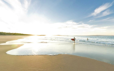
Surfer Girl, Noosa
This is an oldy, but a goody. I was shooting on Noosa beach late one afternoon when I notice 2 girls surfing which is not common. Girls surfing is, but 2 girls surfing alone isn’t. I’m shooting panos with a fisheye lens so there is no use taking pics of them, and I would ask permission first in that situation (which is of course impossible). So I continue shooting around the area and then down by the rock wall, when they decide they’ve finished surfing and it’s time to head in. Perfect serendipity, the lead girl is leaving the water just as I’m shooting, creating one of my favourite panos. You can’t see the girls in the thumb, you’ll need to view the pano 😉

Parliament House, NT
The Northern Territory (NT) in Australia is an incredible place. It is so very sparsely populated that the capital city, Darwin, has only 110,000 residents, while the entire state contains 215,000 people, or around 1% of the Australian population. Considering this I was surprised to find such a large and unique looking building for the State Parliament house, or to be precise ‘Legislative Assembly’. I was also surprised to learn this beautiful building was already 13yrs old. Standing right near it, I figured it was very new, with it’s grand structures and (to me) Asian influences. But that’s the NT, a place chock full of surprises. Parliament House Map.
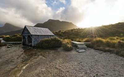
Cradle Mountain Boat Shed
Cradle Mountain National Park is a very popular and beautiful spot in Tasmania. On my last shooting trip to Tasmania I managed 2 trips here. On the first one it was snowing after a cold snap in the middle of summer, this shot is from the 2nd visit about 10 days later when the snow had all melted.
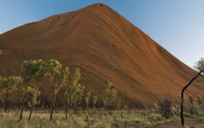
Uluru Southern Face
It’s New Years day, and time to give my blog some well deserved attention….how many other bloggers have decided this today I wonder? My guess is 1 million. The link posted here is to my favourite pano of the moment. It’s of Uluru (Ayers Rock) and was my submission for the ‘Best Of 2007’ on the World Wide Panorama

Stanley, West Side
This is the west side of Stanley, on the wharf.
Subscribe to Panedia News
We promise only send you beautiful, high resolution, panoramic photography posts for your enjoyment…![]()