Virtual Tour Blog by Panedia
enjoy beautiful, high resolution, panoramic photography

Eiffel Tower
The Eiffel Tower is an iron lattice tower located on the Champ de Mars in Paris. It was named after the engineer Gustave Eiffel, whose company designed and built the tower. For a long time it was the tallest building in the world and although it was surpassed it still holds the its famous iconic design. From the top you can have a fantastic view and a real feel of the ‘Pariseinne’ romantic atmosphere.

Round Australia’s Gold Coast
http://www.blurb.com/books/1687198

Mario’s Italian Restaurant – Gold Coast
Since 1989 Gold Coasters have been flocking to Mario’s Italian Restaurant, right near the beach in Broadbeach, to enjoy the great range of modern and traditional Italian dishes available, including seafood, steak, pasta and pizza options. Visitors, families, conference groups and sporting teams all make their way to Broadbeach Mall to dine alfresco, or indoors enjoying the wonderful Italian themed frescoes and relaxed atmosphere. Mario’s famous large serves and extensive menu provide the perfect option for all appetites, including delicious desserts and an extensive wine list. Mario’s Italian Restaurant is the perfect venue for functions, events, conference and group dinners or family celebrations. With its large capacity, both large and small functions can be catered for. The team at Mario’s, with years of experience, can tailor a package to suit your budget and requirements.

Sofitel Apartments – Gold Coast
Perfectly located in the Gold Coast’s cosmopolitan and cultural hub, Sofitel sets the benchmark for world class five star hotels. The property is positioned in the centre of thriving Broadbeach, only 200 metres from patrolled beaches, beachside parks and an array of savvy shops, cafes and restaurants. The hotel features direct access by monorail to Jupiter’s Casino and is just a short stroll to the Gold Coast Convention and Exhibition Centre – the largest regional convention centre in Australia. Broadbeach is minutes south of Surfers Paradise and within driving distance to domestic and international airports for Gold Coast and Brisbane. The precinct boasts over one hundred bars and restaurants and is a lively, safe and vibrant hub of the Gold Coast.

Walk 1000 Miles In My Shoes

HMAS Onslow Submarine Virtual Tour
While shooting Virtual Tours of the HMAS Onslow submarine for the National Maritime Museum I discovered the Sub is a loaner from another Museum in Canberra. That’s quite a loan. From Wikipedia: HMAS Onslow (SS 60/SSG 60) was one of six Oberon class submarines operated by the Royal Australian Navy (RAN). The submarine was named after the town of Onslow, Western Australia and SirAlexander Onslow, with the boat’s motto and badgederived from Onslow’s family heritage. Ordered in 1963, Onslow was laid down at the end of 1967 by Scotts Shipbuilding and Engineering Company in Scotland, launched almost a year later, and commissioned into the RAN at the end of 1968. Although never involved in war, three major incidents occurred during Onslow‘s career. The first occurred in 1972, when a disgruntled sailor who disobeyed orders caused the submarine to dive to almost twice her safe operating depth.[3] As a result, the RAN changed the Submarine Service from being able to ‘conscript’ any sailor for submarine service to volunteer only.[3] The second happened in 1981, when carbon monoxide fumes from one of the diesel generators filled the submarine, resulting in the death of one sailor.[4]Although changes were made to submarine operating procedures, the boat’s company was not provided with any psychological counseling, and the incident report remained classified until 2009.[4] The third was a controversial line-crossing ceremony in 1995, which resulted in restrictions being placed on similar ceremonies aboard RAN vessels.[5][6] During her career, Onslow became the first conventionally powered submarine to be fitted with anti ship missiles, and was successful in wargames: ‘sinking’ a seven ship flotila during Exercise Kangaroo 3 in 1980, and the United States supercarrier USS Carl Vinson at RIMPAC 1998.[7][8][9][3] Onslow was decommissioned in 1999, and was presented to the Australian National Maritime Museum, where she is preserved as a museum ship.

Gigapixel Art Demo
A gigapixel image is a digital image bitmap composed of one billion (109) pixels (picture elements), 1000 times the information captured by a 1 megapixel digital camera. Current technology for creating such very high-resolution images usually involves either making mosaics of a large number of high-resolution digital photographs or using a film negative as large as 12″ × 9″ (30 cm × 23 cm) up to 18″ × 9″ (46 cm × 23 cm), which is then scanned with a high-end large-format film scanner with at least 3000 dpi resolution. Only a few cameras are capable of creating a gigapixel image in a single sweep of a scene, such as the Pan-STARRS PS1 and the Gigapxl Camera.

Tourism Queensland – Green Island
Green Island is a coral cay 27 km offshore from Cairns, Queensland, Australia located within the Great Barrier Reef Marine Park World Heritage Area. The island is surrounded by coral reef and protected in the Green Island National Park.

Tourism Queensland – Port Douglas
Port Douglas is a town in Far North Queensland, Australia, approximately 70 km (40 mi) north of Cairns. Its permanent population was 4,772 at the time of the 2011 census.The town’s population can often double, however, with the influx of tourists during the peak tourism season May–September. The town is named in honour of former Premier of Queensland, John Douglas. Port Douglas developed quickly based on the mining industry. Other parts of the area were established with timber cutting occurring in the area surrounding the Daintree River and with settlement starting to occur on lots around the Mossman River by 1880.

Tourism Queensland – Cairns
Cairns is a regional city in the far north of Queensland, Australia, founded 1876. The city was named after William Wellington Cairns, then-current Governor of Queensland.

Tourism Queensland – Gold Coast
The Gold Coast is a coastal city in southeastern Queensland on the east coast of Australia. The city is 94 km south of the state capital Brisbane.

Tourism Queensland – Sunshine Coast
The Sunshine Coast is an urban area in South East Queensland, north of the state capital of Brisbane on the Pacific Ocean coastline.

Brisbane Floods 2011
A series of floods hit Queensland, Australia, beginning in December 2010. The floods forced the evacuation of thousands of people from towns and cities.[2] At least 70 towns and over 200,000 people were affected.[2] Damage initially was estimated at around A$1 billion[3] before it was raised to $2.38 billion.[1] The estimated reduction in Australia’s GDP is about A$30 billion.[4] Three-quarters of the state of Queensland was declared a disaster zone.[5] Communities along the Fitzroy and Burnett Rivers were particularly hard hit, while the Condamine, Ballone and Mary Rivers recorded substantial flooding. An unexpected flash flood caused by a thunder storm raced through Toowoomba’s central business district. Water from the same storm devastated communities in the Lockyer Valley. A few days later thousands of houses in Ipswich and Brisbane were inundated as the Brisbane River rose and Wivenhoe Dam used a considerable proportion of its flood mitigation capacity. Volunteers were quick to offer assistance and sympathy was expressed from afar. A large mobilisation of the Australian Defence Force was activated and a relief fund created. The head of the recovery taskforce was Major General Michael Slater. The Queensland Reconstruction Authority was formed to co-ordinate the rebuilding program beyond the initial taskforce and a Commission of Inquiry established to investigate all matters related to the floods. The 2010–11 floods killed 38 people in Queensland.[6] As of 26 January, an additional nine people were missing.[7] The state’s coal industry was particularly hard hit. The Queensland floods were followed by the 2011 Victorian floods which saw more than fifty communities in western and central Victoria also grapple with significant flooding. http://en.wikipedia.org/wiki/2010-11_Queensland_floods

Vivid Sydney Macquarie Visions – Virtual Tour
“Macquarie Visions casts a new light onto Sydney’s ceremonial street, celebrating in stunning and immersive light displays, the 200th anniversary and story of two great visionary leaders, Governor Lachlan Macquarie and his wife Elizabeth. The Macquaries’ innovations are revealed with illuminating, theatrical and contemporary light displays in a family friendly free night promenade along the length of the Macquarie Street linking St Mary’s Cathedral to the Sydney Opera House and Circular Quay as part of Vivid Sydney 2010, running from 27 May to 21 June 2010.” [According to the marketing blurb, and they were right.] The 20th June 2010 was a long day. Leaving home on the Gold Coast at 7am for a drive to Sydney 900+km away, I typically have a rest after the 11hr journey. But this was the very last evening of the Sydney Vivid festival, so relaxation was the last thing on my mind. Unpacking the car at the In-laws (apart from my photo gear) I drove to a nearby train station for the 1hr trip into Sydney City. At 8pm on a Sunday night the train and station were deserted. Arriving at Town Hall I briskly walked 1km to the start of the Macquarie Visions event. I was expecting crowds, being the last night of the show, but was pleasantly surprised to find the place sparsely populated nearing 10pm. After 2.5 hours of shooting panoramas & a little video I left the Sydney Opera House, hopped a train from Circular Quay back to Town Hall, then another 1hr train to my car. With my head hitting the pillow at 2am, I was very pleased to have experienced the brilliant lights festival. Following on are single interactive panoramas of each of the main buildings on the tour. 1. St. Mary’s Cathedral – Virtual Tour 2. Hyde Park Barracks – Virtual Tour 3. The Mint – Virtual Tour 4. NSW Parliament House – Virtual Tour 5. State Library of New South Wales – Virtual Tour 6. Sydney Conservatorium of Music – Virtual Tour 7. Sydney Opera House – Virtual Tour Vivid Sydney map containing virtual tours. Vivid Sydney Map, FullScreen with all virtual tours

Holiday Goddess Guide
Our Panoramas used to experience Centre Place in Melbourne. Holiday Goddess Guide

Panedia article on APC mag
Article on APC magazine about our high quality panoramas. APC Mag

Uluru (Ayers Rock) Virtual Tour – Outback
Uluru, formerly known as Ayers Rock, is a place of immense beauty with a definite spiritual aspect. It’s the worlds largest monolith (single big rock), being located in the middle of outback Australia, it towers over the flat surrounding desert. Official Uluru National Park – Link At present you can still climb Uluru, although the owners ask that you don’t. The climb is located on the western face, it’s extremely steep, with chains to help climb portions of it. The climb closes at 8am on any day the temperature is forecast to top 36°C (97°F) I shot the climb from the ground but am not allowed to show it. I chose to respect the wishes of the owners and not climb. Instead I did the 10km (6.2 miles) walk around the base of Uluru. The base walk is amazing. Even if you choose to climb Uluru, make time to walk the base as well. IMO the best way to walk the base is to start at the south car park before dawn, then walk east, counter clockwise around the rock. This way you walk towards the sun as it breaks the horizon… a sunning sight. As the sun gets a little higher & hotter you turn the eastern edge of Uluru and put your back to the sun walking west along the northern rock face. On this section I was going against the flow of hordes of tourists trying to shield their faces & eyes from the intense sun beating down. I shot virtual tours all around Uluru, unfortunately I’m prevented from showing any virtual tours of the northern & north western sides of Uluru. The north face is VERY different from the southern views. It’s heavily pock marked with gashes and rock falls. Looks a little like a person someone has taken a knife too, cutting gashes, and removing skin to reveal organs and brain. Not pretty, but fascinating nonetheless. Uluru map containing virtual tours. Uluru (Ayers Rock) Map with all virtual tours – Link

Sydney Rock Pools – Virtual Tour
Over a couple of stunning winters days in Sydney last year I shot more than 170 virtual tours from Palm beach in the far north of Sydney to Maroubra beach in the south. In the process I visited a LOT of amazing Sydney Rock Pools, which are featured here for your viewing pleasure. [Note: Rock Pools are also known as Sea Baths & Ocean Pools] I’ve covered less than 1/2 of the Rock Pools in Sydney, next time I’m there I plan to shoot many more, eventually having virtual tours of every Rock Pool. If you’re in Sydney with a car, a fantastic day can be had driving all the way to the top of the Sydney coastline at Palm Beach / Barrenjoey Headland, then heading south, stopping at every beach and rocky headland you come across. The Sydney coastline is diverse and beautiful, along with its inhabitants and structures. Ocean Pools History – External Link North Narrabeen Rock Pool Sydney Rock Pools map with virtual tours.Sydney Rock Pools Map – FullScreen Link

Kings Canyon Virtual Tour – Outback Australia
Kings Canyon (Watarrka) National Park is a stunning place, 4hrs drive from Alice Springs in the middle of Outback Australia. It also happens to be 4hrs drive from Uluru (Ayers Rock) You can include it as part of a loop, driving west along the Macdonnell ranges from Alice Springs on Larapinta Drive, then heading to Uluru from Kings Canyon, which is what I did. (4wd recommended) There are 2 main walks at Kings Canyon, a short walk along the valley floor at the foot of the canyon walls. It’s about 500m (1600ft) and takes 30mins at a leisurely pace. Near the end is a beautiful rock pool, depending on the season/rain. The 2nd walk is a much more serious affair of 5.5km (3.5miles) which takes around 3.5hrs to complete. Seeing as this is in outback Australia, which is a HOT place, it’s best to start this walk very early in the morning… or perhaps later in the day. The walk beings with a killer uphill slog, known as heartbreak hill. By the time you reach the top your legs are jelly & your heart pounding. Interestingly this used to be the end of the walk, but lots of people injured themselves coming down the steep hill after walking for 3+hrs. So the park rangers reversed the track to make the hill the start & now have virtually zero injuries. After spending 4hrs shooting virtual tours on the track, my legs really were jelly coming down the gentle slope on the other side of the canyon, I was VERY glad to not be coming down heartbreak hill.

Kakadu Virtual Tours – Anbangbang Rock Art
Earlier this year I was in Darwin shooting for the Northern Territory Library. I organised for one extra day in my schedule to allow me to zoom out to Kakadu & shoot some virtual tours. It’s a 3hr+ drive each way from Darwin to Jabiru in the Kakadu NP, so I didn’t expect to have much time for shooting. Plus the wet season wasn’t over yet, so most places were inaccessible. Even so the couple of places I could get to were amazing. Official Kakadu National Park Link The Nourlangie and Nanguluwur art sites are a short drive from the Kakadu visitors centre and about a 1.5km (1 mile) walk. The art & rock shelters are amazing to see, and very worthwhile.

Port Arthur Virtual Tours – Tasmania
Quite some time ago I was in Tasmania shooting hundreds of virtual tours. One morning while staying in Hobart (capital city) I got up at 4am to drive out to Port Arthur (1.5hrs away) to shoot virtual tours at sunrise. Driving 1.5hrs for a sunrise shoot is always a little risky. It’s still dark when you leave, so all you have to go on are the weather reports from the night before & what clouds you can see locally in the dark. Fortunately this morning was beautiful. The Port Arthur ruins are some of the oldest in Australia and sit on a beautiful waterway. If it wasn’t for the cruel & severe life convicts endured here… I’m sure it would have been quite lovely. Port Arthur Ruins at Sunrise Port Arthur is the most popular attraction in Tasmania, the heritage listed park is wonderfully maintained, with a large and informative visitors centre. Port Arthur Ruins of the church. Port Arthur map containing virtual tours. Port Arthur FullScreen Map Link Official Port Arthur Website Link

Floriade Canberra
50+ Floriade Virtual Tours. The Annual Canberra flower festival – Floriade is on right now… up until the 11th of October 2009. If you get a chance… go, it’s beautiful. Now I’m not a flower lover in particular, but they build all sorts of images in flowers, it’s amazing stuff. Official Floriade Site Link When I shot the festival last year I happened to arrive in Canberra about 1hr before it finished for the year. I not only witnessed the amazing flowers, but the aftermath, as festival volunteers got to dig up whatever plants they wanted. Floriade Aftermath. (Only for volunteers) The fact everything was about to be destroyed also meant I could walk all over the flower beds as well, getting to the middle of them for virtual tours, which was great. I would have loved to shoot pole panoramas there as well, but unfortunately time didn’t permit.

Surfers Paradise Dust Storm
With all the noise about the Sydney Dust Storms this morning we here in Queensland were watching with interest… until about lunchtime when the dust storms hit us as well, 1000km (620 miles) north of Sydney. Surfers Paradise Beach – Under Dust. I figured if the dust got so thick I couldn’t see buildings about 300m (1000ft) away I’d head into Surfers Paradise and shoot some virtual tours for posterity. As it turns out we got the pea soup thick dust, so I took the shots. Surfers Paradise Beach – Typical Morning. Here is the full set of 4 virtual tours I shot today. You can also check them out on maps in the virtual tour player. Click the ‘map’ button, on the lower right control panel.

Alcatraz Virtual Tour
The best Alcatraz virtual tour on the web is right here: Alcatraz Virtual Tour. View the full map version with audio here: Alcatraz Virtual Tour with Audio. Alcatraz Virtual Tour – Main Cell Block There are plenty of Alcatraz Virtual Tours on the web, but apart from ours none of them contain high resolution, best quality full spherical, full screen virtual tours with hotspots, mapped on google maps & containing audio recorded live at the time. Alcatraz Virtual Tour – Officers Club Alcatraz Virtual Tour – Exercise Yard Alcatraz Virtual Tour – Control Centre Alcatraz is an incredible place and it’s well worth spending a few hours to half a day there. At some times in the year they have an early boat over to the island. It arrives well before the crowds. Get that boat & take advantage of the crowd less Alcatraz. Here’s the official cruise company where you can book your Alcatraz tickets online. When I visited Alcatraz Island to shoot these virtual tours a funny thing happened. At around midday I was back at the dock waiting for the ferry to arrive when off the boat hopped the guys from Mapjack, ready to shoot their own virtual tour of Alcatraz. Here is me on Alcatraz just finished shooting virtual tours, as shot by Mapjack, another virtual tour company. For more info on Alcatraz go to the official National Parks website here: Alcatraz Island

Adelaide Virtual Tour
With over 500 virtual tours of Adelaide you’ll find plenty to see on our virtual tour site. Adelaide is a beautiful city full of old buildings & churches (by Australian standards). The City area is completely surrounded by massive parks, some of which contain sports fields & botanical gardens. Here you can view over 60 Adelaide Botanical Gardens Virtual Tours. Victoria Square – Adelaide Virtual Tour Glass Footbridge – Adelaide Virtual Tour Black swan & paddle boats on The River Torrens – Adelaide Virtual Tour Botanic Gardens of Adelaide Virtual Tour Bicentennial Conservatory – Adelaide Virtual Tour Port Adelaide Virtual Tour – Queens Wharf Henley Jetty – Adelaide Virtual Tour

Mt Kosciusko Virtual Tours
Back in October 2008 I had the opportunity to shoot virtual tours from the top of Australia’s Tallest mountain, Mt Kosciusko. I put together a separate map of the 46 Mt Kosciusko Walking Track Virtual Tours. This area is also known as the Snowy Mountains and the Australia Alps. It’s located in Kosciusko National Park. Of course Australia being the flattest continent on Earth, our mountains are more rolling hills than ‘mountains’. This is borne out by the fact there’s a nice wide walking track all the way to the top, while back in the day you could drive to the top. They closed the road in the 1970’s though, as parking at the top of our tallest mountain was becoming an issue. A Virtual Tour of Mt Kosciusko – From the top. The official record lists the height of Mt Kosciusko at 2228m (7310 ft). My camera mounted GPS claimed a height of 2232m (7322 ft), you can decide which one you want to believe. (Hint: GPS is generally not very accurate at measuring height, although very close in this instance) There are 2 walking tracks to the top. I chose the shorter one, a 13km (8 mile) return, which runs from the top of the Thredbo Chairlift. The lift costs $28 for a return trip in summer and takes about 10mins. It’s a beautiful ride up. The walk wasn’t too hard consisting mostly of undulating hills. In October I had to cross about 6 snow drifts, some of which were quite long, and near to the top of Kosciusko a little steep and slippery as well, but passable with normal foot gear. I did a day trip from Canberra out to the Snowy Mountains. It’s a long day, with a 2hr drive at each end, but well worthwhile. A couple of kilometres in there is a lookout to Mt Kosciusko. Footbridge over a mountain stream, Mt Kosciusko National Park.
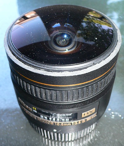
Shaving The Nikon 10.5mm Fisheye
Talking about shaving the Nikon always reminds me of a lunch I had with friends one Sunday afternoon. We were eating bread rolls with meat & salad when I happened to read the label for the ham. It read ‘Lightly Shaved Hungarian’ which none of us had heard of, so I pronounced, “I’ll have a lightly shaved Hungarian please, my favourite kind!” We all cracked up laughing, my wife included. Not funny? I guess you had to be there All joking aside, shaving the hood off the Nikon 10.5mm is a serious although not too difficult process. If you’re not certain you want it shaved, turn back now as you can’t glue the hood back on later. Although you could have it repaired with a new one, at considerable expense I expect. In fact talking with NPS Australia (Nikon Professional Services) at a motor race I heard the best example of a shaved 10.5mm they’d ever seen was one done ‘professionally’. According to them a gentleman bought a 10.5mm and a hood as a spare part. He had the spare part hood cut perfectly, then had Nikon install the cut hood onto his new 10.5mm. I’m told the result looked like it came from the factory. The other end of the scale looked more like a dog had ripped the hood off with it’s teeth The method I’m about to describe will provide a good (although not factory) finish, and require about $6 worth of tools from your local hardware store. It requires no workshop or other gear, and I actually performed the procedure while staying at a hotel in Sydney. Required Tools: 1) Small hacksaw, with very fine teeth that have no warped pattern, ie the teeth run perfectly straight. The example shown here cost me Aud $4.95 at the local Bunnings hardware store. I looked for an extra blade, but all the examples they had contained the warped pattern in the teeth which I didn’t want. I should have just bought 2 hacksaws, but I was too cheap. (Note: you don’t need ‘the’ hacksaw I’m showing, any hacksaw will do the job, but a small one does give you more control, and feel as you cut through the plastic.) 2) Electrical tape. 3) Pencil. 4) Sheet of paper. This image also shows masking tape which I didn’t end up using. Procedure: Step 1 Figure the point at which you will cut the hood off. I chose just under the lowest point of the hood petals. Elevate the pencil a little (I did use the masking tape after all) and rotate the lens while holding the pencil against the hood. This will mark out your cut line. It will be rough, but don’t worry, we’ll deal with that in the next step. Step 2 Using the electrical tape, mask the bottom of the line drawn in step 1. Be sure not to cover the line. Run the tape around the lens 5-6 times to build up some […]

350+ London Virtual Tours
After 2 weeks in Japan Rick landed in the UK ready to start shooting London virtual tours. He spent his time shooting mainly in the Central London areas, covering plenty of the major sites such as: Buckingham Palace Virtual Tour: Trafalgar Square Virtual Tour: London Eye, from Jubilee Gardens, Virtual Tour: Horse Guards Virtual Tour: Piccadilly Circus Virtual Tour: There are also plenty of multi monitor wallpapers from Central London on our Desktop Wallpaper site. [members]

Japanese Virtual Tours
Our intrepid pano photographer Rick headed overseas late last year. His destination, London UK, with a couple of weeks in Japan on the way. Rick experienced 2 sides of Japan in his 2 weeks, the City – Tokyo, and the Country – Hokkaido. Plenty of stunning photography was produced in the short time Rick had available. Here are a few examples: Shibuya Station, Tokyo Tomakomai Shrine, Mount Tarumai

Wallpaper User Profile: Greg P
From first conception [Panedia Wallpaper](http://wallpaper.panedia.com) was made for multiple screen users. Panoramic photography looks beautiful stretched across two, three or even more screens. At wallpaper we try to straight-up cater for just about every user with 120 variations on each image, some stand alone, some which work together. No matter how many we offer there’ll always be exotic, non-standard screen setups which is why we also offer the massive original file for our paying members. Greg P is an [IT developer](http://wetapple.com/), [web master](http://piperhosting.net/) and Dad living in the Puget Sound area of Washington state. His setup is a 24″ alumninium iMac with a vertical Samsung 740BX 17″ LCD. The setup up close. The setup in context. To get them spanning correctly and at the correct orientations across the two screens Greg uses a custom Photoshop template with cropping masks of each monitor. The original wallpaper is dropped in behind, scaled and positioned as desired, cropped and exported to “left and a “right” directories with the same filename. As an ex-dual-screen-computer-user, now a single screen 24″ iMac user this setup is exactly what I’ve been looking at trying. Greg says there’s polarisation issues with the vertical screen as it’s not made to be viewed at that orientation but it’s simply a matter of getting used to it before forgetting it’s even there. The widescreen plus portrait screen setup makes sense. Some applications: mail, websites, documents, are more ideally suited to great horizontal space while others: image and video editing, calendars and movie watching, are suited to a widescreen landscape setup. I’m impressed with Greg’s setup and the way he uses Panedia wallpaper but I’m jealous of his *real*, panoramic views of Puget Sound, Seattle and Mt Rainier from his home and office:

Google Streetview Australia
Today Google launched Streetview in Australia, and it is brilliant. The coverage is simply mind boggling. Included is every major city or town in the entire country it seems. Of course Streetview only shoots from streets at present, so they miss a lot, like Fraser Island, Uluru, National Parks, beaches, trails, mountains, waterfalls, accommodation, tours, shows etc but the vast coverage is great for getting an idea of a place. In addition to incorporating Streetview scenes into Panedia, we’ll use it extensively to scope out places for high quality photography in cities and towns we’ve not been to before. For the Streetview launch, Tourism Australia has chosen 8 virtual tours to showcase Streetview Oz. We have shot all the same places except Perth. So I’ve created a comparison gallery of the best Streetview images as chosen by Tourism Australia and the shots we took at the same place. High resolution image comparison gallery: http://photos.panedia.com/p616902282 (I have changed the Streetview choices a little to make them match up better with the spot we shot from, but in every case the Streetview quality is the same.) Surfers Paradise – Streetview Surfers Paradise – Panedia Canberra – Streetview Canberra – Panedia Alice Springs – Streetview Alice Springs – Panedia Sydney – Streetview Sydney – Panedia Check out all the comparison images in high resolution at our gallery here: http://photos.panedia.com/p616902282

‘Best Of’ Melbourne part 1
As a former Melbournite, it was a pleasure to be able to photograph the city I grew up in and show it off with a thousand or so panoramas! Looking back now, I thought I’d stop and compile a list of the best stuff, and what I think sums up the character of the city. So, if you’ve never been, here’s what you’re missing! Melbourne is a beautiful city, and has a justified reputation for being one of the world’s most liveable too. Whatever your cup of tea is, be it food or fashion, art or sport, Melbourne has you covered. Royal Botanic Gardens The Royal Botanic Gardens is a short stroll from the city and St. Kilda Road, making it a popular spot during lunchtime. On weekends you’ll find joggers, picnickers and people just out for a stroll. The Moonlight Cinema makes for a great night out under the trees in summer. Birrarung Marr A relatively recent makeover has turned the area between Federation Square and the Olympic Park sporting complex, now known as Birrarung Marr into a fantastic space containing many art installations, and catering for touring events such as Cirque du Soleil. Southbank Southbank lies on the south bank (funny, that) of the Yarra River, and features a promenade lined with cafes and bars, as well as fine dining and retail precincts with specacular views back towards the city. Southbank is also home to the Eureka Tower and Crown Casino. Federation Square Though Federation Square was for a long time considered a bit of a white elephant, the city has now embraced it for what it is, a fantastic piece of urban planning that brings together several areas of the city. It is home to the NGV Ian Potter Centre, ACMI and many hugely popular restaurants and bars. Federation square has become a focal point for the city, hosting free public events and acting as a meeting place for Melburnians. Stay tuned, in the next entry we’ll explore some of Melbourne’s other iconic areas. -Rick

5000+ Mapped Virtual Tours
5052 Virtual Tours are now online at Panedia. I’d been planning to post at 4000, then 4500, but before I’ve had a chance, we’ve hit 5000. I’ve been shooting in Byron Bay, and Sydney. While Rick has been all over the place. Shooting heaps of panos within an hour or 2 of Melbourne. We also have every intersection + a lot more in the Melbourne City Grid, plus we have audio for each panorama there. And we’ve added a new size of panorama to the map…almost double the previous largest size….while we’ve added auto panorama sizing based on your browser window size as well. We’ve also started shooting aerial panoramas in Canberra at the recent Balloon festival. Watch this space, there’s more to come on that subject. I’m off to Sydney again in an hour for the Google Developer day tomorrow, plus I’ll shoot a lot more Sydney for Panedia. I’m planning to shoot northern beaches over the next week. I’m also hoping to attend the Apple store opening on the 19th of June. I’ll leave you with this fireworks pano (complete with audio) from ‘Cracker Night’ at Surfers Paradise on the Gold Coast 2 weeks ago. Cracker Night – Surfers Paradise
Email Confirmation
There’s not much that annoys me more online than having to sign up unnecessarily for free services. I went as far as to make a [complete website](http://uselessaccount.com/) making fun of the experience. When we began planning [Panedia Desktop Wallpaper](http://wallpaper.panedia.com) one of the first decisions we made was paid members would be the only user that required sign up, if you want free content, you could get it without barrier. If you have an account, you are a paying customer. At first the sign up process instinctively included email confirmation for accounts. As internet users we’re highly trained in this procedure — sign up, refresh email, click confirmation link, account activated. As a developer who’s implemented sign up systems multiple times, creating a sign up system around email confirmation wasn’t something I questioned. Until new users weren’t getting confirmation emails. We knew this would happen, with spam filters having no reason to trust us, users not checking spam folders, server side filters and plain human error. The best we could do was tell them to check their spam and add the question to the FAQ, I mean, we *need* email confirmation, right? Wrong! Accounts at other online services required email confirmation as a layer of protection against robots signing up for multiple *free* accounts. We don’t have free accounts, our barrier to robots is *money*. We dropped email confirmation, removed an extra step from the cumbersome process of signing up and made our lives easier by not having to deal with lost confirmation emails.
Introducing Panedia’s Pano Site. (Preview)
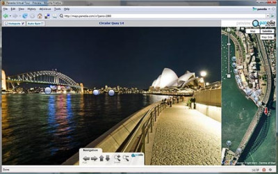
Sydney Opera House, Australia. (Hotspots Off) Before we start I’d like to point out the naming convention we’re using for our panorama/mapping sites: http://maps.panedia.com is our ‘MAPS’ site…big map, small panoramas by default. http://pano.panedia.com is our ‘PANO’ site, fullscreen panoramas, dynamic hotspots and small map. Both sites use the same content, albeit in different sizes and formats, but they present the world in a very different way. ‘Maps’ is a top down look at the world, whereas ‘Pano’ is a ground based tour through the world. OK simple explanation over, lets look at the details. Stanley, Tasmania, Australia. (Mouseover Panorama Hotspot) In the Pano site we’ve managed to integrate the panorama and google maps completely. So mousing over a hotspot in the panorama updates the map, while mousing over a marker on the map, updates the panorama. All the hotspots inside the panorama are dynamically generated based on a number of factors in our algorithm. Each hotspot when moused over opens a large thumbnail image of the view from that panorama position. The hotspot window also contains the distance & bearing to that panorama from the one you are in. Of course you can turn the hotspots off an enjoy the view anytime using the ‘Hotspot’ checkbox on the top left of the window. Alice Springs, Northern Territory, Australia. When you mouse over a hotspot in the panorama, the map scrolls or jumps (depends on the distance) to the marker you are viewing. This gives you an aerial view of that location, while the hotspot shows you an image from that location. Clicking the hotspot or map marker will take you to the clicked panorama. Circular Quay, Sydney, Australia. (Mouseover map marker) When you mouse over a marker on the map, the hotspot in the panorama view will contain a locating arrow and hotspot to show you the approximate position of the panorama you have selected. At any given time the map contains a lot more markers than the panorama contains hotspots, so there are many more options to view on the map side. ‘Map Site’ button takes you to the Big Maps view. On the map side of the screen we have the standard Google Maps zoom control & the option of Map or Satellite view. We’ve removed Hybrid & Terrain for the moment just to save space. In addition we’ve added a ‘Map Site’ button. Clicking this button will take you to the ‘Maps’ site at maps.panedia.com, and centre the big map on the place you’re currently viewing, as seen below: ‘Maps’ View for exploring large areas. Once in this view, navigation of large areas is easier, as is searching and finding a place to explore….when you’re ready to jump back to the ‘Pano’ view with hotspots, just click on the panorama you want to view (by clicking the map marker), the small panorama will appear as seen here: Small panorama in ‘Maps’ view. To view this panorama in the ‘PANO’ view mode, just select ‘Hotspots’ on the […]

Panedia vs Streetview
People familiar with Google’s Streetview, which is basically panoramic virtual tours on maps, would be forgiven for thinking Panedia is just another ‘me too’ effort. Allow me to show you how this is not the case. There are fundamental differences between Streetview & Panedia, which produce vastly different end results. One isn’t better than the other, they are both great technologies, but they both serve very different purposes and potentially different markets. Core Philosophies Google Streetview Goal: Add visuals to maps so people can look around on the ground, enabling greater understanding of a specific location or area. [Link Out] Result: Attach panoramic cameras to cars and drive down all streets in a city taking images. Add panoramas to maps. [Larry Page’s Idea] Panedia Goal:Use Panoramic Virtual Tours to produce the worlds best destination content and create a visual archive of our changing world. Make the content available in as many mediums as possible. Result: Use professional photographers & equipment along with extensive automated workflows to produce some of the most beautiful destination content available. Shooting places of interest & of historical value. Use the content in may ways including adding it to maps for online viewing. Practical Results As you would expect these philosophies lead to very different results where Street View & Panedia overlap, ie on maps. Panedia = Low quantity of extremely high quality panoramic virtual tours on maps.Google Street View = Vast quantity of low quality panoramic virtual tours on maps. Google Streetview – Cnr Geary & Stockton St – Union Square, San Francisco. Panedia = Low quantity of extremely high quality virtual tours on maps. Panedia – Cnr Geary & Stockton St – Union Square, San Francisco. Differing Markets So what markets are most suitable for each technology? Streetview offers 10’s of thousands of low quality panoramas of a given city/area making it ideal for looking up a particular address to see what it’s like at that spot. The recent mashup of Streetview content on Trulia, a major US realestate site, is an outstanding use of Steetview in this context. Travelers though, need to know something about a city before going to Streetview as no one has time to look through 10,000+ panoramas. Of course you can search for particular places in Google maps and look at them in Streetview, but you still need to know interesting places to search in that city before starting. There is far too much choice to just start clicking randomly on Streetview panoramas. Panedia on the other hand will offer 100’s to 1000’s of very high quality panoramas of a given city/area. These panoramas will mainly be shot in areas of interest for travelers. Therefore the viewer doesn’t need to know anything about a city before discovering amazing places to experience. On Panedia those places have already been selected and shot by professional photographers. The viewer doesn’t need to open a panorama to find interesting places to see, as each one has a thumbnail image of the best […]

A Refreshing Take on Usability
Last week Ben Scheirman over at the Flux88 blog did a quick review of an important feature on our Wallpaper site. He noted that we read user information from visitors to wallpaper.panedia.com and customise the site to their needs as best we can. This feature started as a simple concept that grew to become a very useful aspect of the site. We have plans to further extend this type of functionality over time. Thanks Ben.
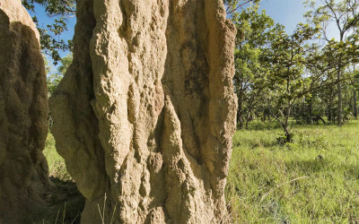
3500+ Mapped Virtual Tours
3513 Virtual Tours are now online at Panedia. With hundreds more in the pipeline, 4000 should be coming up soon. I’ve been busy stitching panos from Darwin in the Northern Territory of Australia. Panos I shot back in December that haven’t been prepped until now. Among those panos are amazing huge termite mounds and waterfalls in Litchfield National Park about 90 minutes drive outside of Darwin, & the Aviation Museum near the Darwin Airport. Here’s a view inside the wheel bay of a B-52 bomber at the Aviation Museum. The B-52 is the centerpiece of the museum taking up much of the total floor area.

Introducing Panedia Desktop Wallpaper
With Panedia Wallpaper I’m introducing the first of many products and services to come out of the huge Panedia panoramic content library. The site has been up for a few weeks testing in narrow release, today we give it the official heave ho into wide release. (Tell your friends about it Panedia Desktop Wallpaper contains over 40 wallpapers at present, with a ‘Free Daily’ wallpaper being added every day. The daily wallpaper update is available free for 24hrs only, before it goes into the members gallery. There is also a public gallery (free) which is added to monthly. Each wallpaper on the site is available in 16 sizes from 800×600 to 2560×1600 for single, dual and triple monitors in the 3 common ratios 4:3, 5:4 & Widescreen (16:10). We produce 130 separate images for each wallpaper to provide all the sizes for MAC and PC computers. Members (paid) have access to all wallpapers at all times, plus the master files used to generate the wallpapers. With these files members can cut up their own wallpaper sizes, for up to 4 or 5 monitors. We’re working on tools to enhance this capability in the short to medium term. Members can also use Panedia Wallpaper as a form of Service, I’ve called it WAAS (Wallpaper As A Service) for want of a better term, whereby they need not horde images on their computers for wallpaper. A member can access the site at any time from any computer and download the exact size image(s) they require. Using the ‘Set As Desktop Background’ function of Internet Explorer, Firefox or Safari the wallpaper image is then set as the computer wallpaper. VERY quick & VERY simple. Each of the wallpaper download pages link into to our pano/maps site maps.panedia.com to provide a virtual tour view & show where the image was photographed. Eventually users will be able to link back and forth on a single panorama between all the Panedia sites depending on what they require. Panoramas, Virtual Tours, Maps, Wallpapers plus more. Finally there are RSS feeds to the galleries & Free Daily Wallpaper to make grabbing the images you like easy, and we’re in the process of setting up some interesting competitions to allow viewers to win subscriptions and more. Please have a look at the new site, and let us know what you think of it, as the site will evolve according to the feedback we receive. We’d particularly like to hear from you if you have any difficulty with any part of the site. Aaron Spence CEO & Lead Photographer.

So here I am
I’m Ricky, the first non-Aaron photo-taking-guy. I also don’t have a title yet. Photographer is OK, it fits the bill, but it seems too mundane for something as outrageously cool as Panedia. As Aaron said, my background is in commercial photography, and I come to Panedia from RMIT University, where I was a student and more recently the photography department technician. Now THAT was an inadequate job title, I tells ya. Basically I fixed stuff what needed fixin’, and that meant I picked up a few basic engineering and electronics skills along the way, which I will be bringing to Panedia in the form of some cool gadgetry to help future photographers do their job faster and more accurately, as well as my hopefully self-evident photographic talents! At the moment I’m working on our vast backlog of images from the recent Fraser Island junket/meet-and-greet/Panedia team-building exercise ’08, polishing them up ready to be put through the Panedia production line. One of the issues Aaron and I have encountered along the way thus far now that photography is coming in from different streams, is how do you keep things consistent in terms of the overall ‘look’ of the images. As photographers, we all have our own ideas about what constitutes a nice-looking image. It’s open to interpretation at the best of times, but with something like Panedia it is vitally important that the look and feel of the imagery is relatively consistent. Over the coming months we will be developing a ‘look book’ that contains presets for the basic conditions we will be shooting in, which should lead to being able to shoot in a multitude of different lighting scenarios, and being able to produce a panorama that will not look out-of-place alongside panoramas that have perhaps been shot months ago by a different photographer in different conditions. So keep an eye out for a bunch of my photography coming online shortly, and I’ll be blogging here about anything that takes my fancy, photography, gadgetry or travel-related. In the meantime I leave you with a lovely shot of the TSS Maheno wreck on 75 Mile Beach, Fraser Island, QLD. -Rick flickr stream
New Panedia People – Rodrick Bond
Rodrick…or Rick as we call him around here, started shooting for us full time a couple of weeks ago. In that time he’s already added hundreds of panos to Panedia. From Fraser Island to The Melbourne Motor Show and the Melbourne Grand Prix, he’s been very busy. Rick is a talented still and pano photographer whose work can view viewed on his personal site www.rodrickbond.com. He ‘s a graduate of RMIT (Royal Melboure Institute of Technology) with a bachelor of photography. He also builds some very cool stuff, so he’ll be working on R&D for our photographic processes and helping set up systems to make life easier for future photographers. Contrary to the photo seen here of Rick on Fraser Island, he’s not a crazy homeless man, although Rick might say otherwise. And finally Rick will be blogging here as well, about things that strike his fancy.

Hello World, My Name is Jim
Aaron gave me a [quick introduction](http://blog.panedia.com/2008/03/27/new-panedia-people-jim-whimpey/) yesterday but I want to expand on that a bit. I’m the guy that does… lots of things. That’s why we’re having trouble giving me a title I can put on my business cards. I’m a web designer, web developer, programmer, [wordpress](http://wordpress.org) lover and wrangler, database designer, UI designer, tester, blogger, server admin and bug hunter, it’s hard to put a banner over all of that. For an example of what I’ve worked on so far there’s [Panedia’s Wallpaper website](http://wallpaper.panedia.com/) which I created from start to finish. There’s this blog too. As for blogging, I want to primarily write about the things I enjoy reading about at other “business” blogs — my philosophy for writing in general — write for my own taste. When it comes to business blogs, anything behind a product or service, I don’t want to be sold the product, I already like the product, that’s why I’m looking to read more about it at the blog. What I do want to read about is the process, how that product exists and what decisions were made to get there, I want to know about the things you don’t see looking in from the outside. One of my favourite applications on the Mac, [Things](http://culturedcode.com/things/) has a great example of a product blog. They go into great detail about the motivation and process of new features. One post that particularly stands out was on the [creation of the recurring task UI](http://culturedcode.com/things/blog/2008/02/habemus-dialogum-we-have-a-dialog.html). It includes screenshots of the many layouts they tried before settling on the ideal solution. It’s really interesting stuff that without a blog, you just don’t see. Aaron and I are constantly going through this process when making decisions and planning new features for the products we work on. The process of making these decisions is extremely interesting to me and so, I’m sure, would be just as interesting to outsiders. Elsewhere I write, link to and comment on things that interest me at [Valhalla Island](http://valhallaisland.com) and I’m a huge [Twitter](http://twitter.com/jimwhimpey) user.

New Panedia People – Jim Whimpey
Panedia is growing. In addition to yours truly we now have 3 amazing people working on different aspects of Panedia. I’ll be introducing the team via the blog over the next short while. A couple of the team members will also be blogging here. Jim Whimpey: We’re still working on his official title, but he’s responsible for our websites. He’s also our master of blogging & pano photographer in training, while completing an IT degree at University. If you’re wanting to get to know Jim, his blog is at Valhalla Island, while he tweets at http://twitter.com/jimwhimpey.

3000+ Virtual Tours
We hit a big milestone yesterday, 3000 virtual tours. We should have hit it a few months ago, when I finished the panos I shot in the Northern Territory, but I haven’t finished them yet. Instead I was at www.easterfest.com.au on the weekend and shot another 75 panos there, taking our total to just over 3000. So much has been going on over the last couple of months that I can’t begin to explain it all, suffice to say, many new announcements & sites will be forthcoming over the next short while. We also have hundreds more panos in the pipeline, so the 4000 pano milestone will be coming up soon.
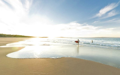
Surfer Girl, Noosa
This is an oldy, but a goody. I was shooting on Noosa beach late one afternoon when I notice 2 girls surfing which is not common. Girls surfing is, but 2 girls surfing alone isn’t. I’m shooting panos with a fisheye lens so there is no use taking pics of them, and I would ask permission first in that situation (which is of course impossible). So I continue shooting around the area and then down by the rock wall, when they decide they’ve finished surfing and it’s time to head in. Perfect serendipity, the lead girl is leaving the water just as I’m shooting, creating one of my favourite panos. You can’t see the girls in the thumb, you’ll need to view the pano 😉

Parliament House, NT
The Northern Territory (NT) in Australia is an incredible place. It is so very sparsely populated that the capital city, Darwin, has only 110,000 residents, while the entire state contains 215,000 people, or around 1% of the Australian population. Considering this I was surprised to find such a large and unique looking building for the State Parliament house, or to be precise ‘Legislative Assembly’. I was also surprised to learn this beautiful building was already 13yrs old. Standing right near it, I figured it was very new, with it’s grand structures and (to me) Asian influences. But that’s the NT, a place chock full of surprises. Parliament House Map.
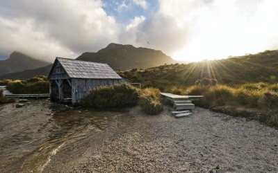
Cradle Mountain Boat Shed
Cradle Mountain National Park is a very popular and beautiful spot in Tasmania. On my last shooting trip to Tasmania I managed 2 trips here. On the first one it was snowing after a cold snap in the middle of summer, this shot is from the 2nd visit about 10 days later when the snow had all melted.
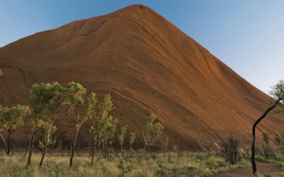
Uluru Southern Face
It’s New Years day, and time to give my blog some well deserved attention….how many other bloggers have decided this today I wonder? My guess is 1 million. The link posted here is to my favourite pano of the moment. It’s of Uluru (Ayers Rock) and was my submission for the ‘Best Of 2007’ on the World Wide Panorama
Subscribe to Panedia News
We promise only send you beautiful, high resolution, panoramic photography posts for your enjoyment…
![]()