Virtual Tour Blog by Panedia
enjoy beautiful, high resolution, panoramic photography
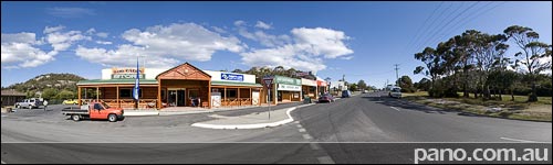
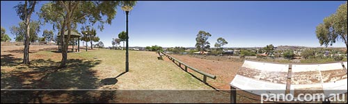
Bicheno, Town
See this Virtual Tour in FullScreen High Definition mode. Opens In New Window + Audio FullScreen Virtual Tour [1.8MB] This virtual tour shows the town of Bicheno & the Tasman Highway. The highway is the main (and only) road through town and runs from Hobart to Launceston via the east coast of Tasmania. Bicheno has a population of around 700 so it’s a lovely small town. See Full Size Google Map with all Bicheno Virtual Tours – Click Here.INSERT_MAP Bicheno Reviews, Links, Websites – Click Here
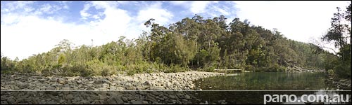
Bicheno, Douglas Apsley NP
See this Virtual Tour in FullScreen High Definition mode. Opens In New Window + Audio FullScreen Virtual Tour [2.2MB] Douglas Apsley National Park is only a few kilometres from Bicheno. In this virtual tour we’re standing in the Apsley river, on th edge of the Apsley Waterhole. Find out more about this National Park at the Parks Website here. See Full Size Google Map with all Bicheno Virtual Tours – Click Here. Bicheno Reviews, Links, Websites – Click Here
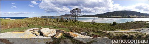
Bicheno, Top Of The Island
See this Virtual Tour in FullScreen High Definition mode. Opens In New Window + Audio FullScreen Virtual Tour [2.5MB] The high point on Diamond Island allows us to see the lay of the land. From here we can view the sand bridge which only forms at low tide & the buildings of Bicheno off in the distance to the South East. The island is home to thousands of penguins, making it very important to tread lightly. Daylight hours see all the penguins out fishing except for a few of the young which can be spotted in burrows here and there. See Full Size Google Map with all Bicheno Virtual Tours – Click Here.INSERT_MAP Bicheno Reviews, Links, Websites – Click Here
Bicheno, Diamond Island Bridge
See this Virtual Tour in FullScreen High Definition mode. Opens In New Window + Audio FullScreen Virtual Tour [0.9MB] Diamond Island is a tiny nature reserve only 100m (330ft) off the coast. In fact, at low tide there is usually an hour or so to walk over to the island on dry sand. The island was declared a nature reserve in 1977 because of its importance as a large penguin rookery. We’ll have a closer look at the island tomorrow. See Full Size Google Map with all Bicheno Virtual Tours – Click Here.INSERT_MAP Bicheno Reviews, Links, Websites – Click Here
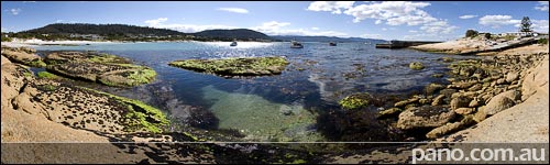
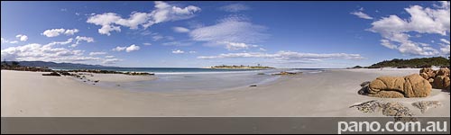
Bicheno, Clear Waters
See this Virtual Tour in FullScreen High Definition mode. Opens In New Window + Audio FullScreen Virtual Tour [2.3MB] Bicheno is a wonderful little seaside town about half way up the east coast of Tasmania. With crystal clear waters, white sandy beaches and huge rocky outcrops it makes for great pictures. We’ll spend a few days here having a look around. See Full Size Google Map with all Bicheno Virtual Tours – Click Here.INSERT_MAP Bicheno Reviews, Links, Websites – Click Here
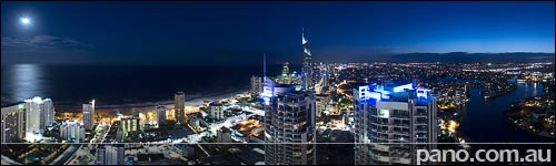
Gold Coast, Surfers Penthouse
See this Virtual Tour in FullScreen High Definition mode. Opens In New Window FullScreen Virtual Tour [1.7MB] Shot from the Chevron Renaissance, this sub-penthouse virtual tour gives a good view over the Gold Coast. In this virtual tour we can see the Q1 currently the worlds tallest residential building, and some of the vast network of canals on the Gold Coast. We can see the famous Gold Coast beaches, the ocean, the city lights shining bright that dim heading west out to the suburbs & the mountains. The Gold Coast is wonderful & diverse place, but we’ve only touched on a part of it. When next here we’ll look inland at the hinterland of sub-tropical rainforests & mountains.

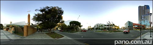
Gold Coast, Cavill Mall
Cavill Mall Surfers Paradise. The epicenter for Gold Coast tourism. During the week this place is often quiet, but on weekends it can be jam packed. There’s also markets here on Friday nights. It’s a great spot you should see when visiting the Gold Coast, but make time to see the rest, as the Gold Coast is much more than Surfers Paradise. In this pano we’re about 50m (164ft) from the Surfers Paradise beach virtual tour of last week.
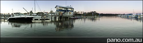
Gold Coast, Southport CBD
See this Virtual Tour in FullScreen High Definition mode. Opens In New Window + Audio FullScreen Virtual Tour [1.9MB] Back in Southport, which is sort of the Gold Coast CBD. Scarborough is the main street through Southport, although all the shopping is a block north of here. From here we see the Southport RSL on the opposite corner & Southport Central across the street.
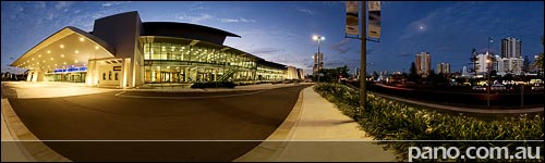
Gold Coast, Convention Centre
See this Virtual Tour in FullScreen High Definition mode. Opens In New Window + Audio FullScreen Virtual Tour [1.4MB] Now that we’ve Virtual Toured Gold Coast beaches from south to north, we’ll head south again to Broadbeach, where the new Gold Coast Convention & Entertainment Centre lives. Interestingly this Broadbeach Virtual Tour was shot exactly 1 year ago today. It was from the 1st series of panos I did with my current setup. Another piece of useless information is that my company (formerly known as Fusion Creative) did a multimedia cd-rom of this site & facility for the Jupiters consortium that eventually won the bid to build & run the centre. I think we charged $5,000 – I think they charged $120 million
Gold Coast, Sanctuary Cove
See this Virtual Tour in FullScreen High Definition mode. Opens In New Window + Audio FullScreen Virtual Tour [1.3MB] Sanctuary Cove is a luxury mini town on the northern end of the Gold Coast. Complete with paved streets and beach town themed shopping areas, it’s a fun place to visit & have a meal. Sanctuary Cove is also home of the largest on water boat show in the Asia Pacific region.
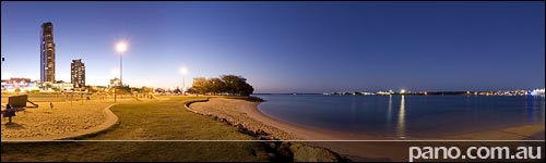
Gold Coast, Paradise Point
See this Virtual Tour in FullScreen High Definition mode. Opens In New Window + Audio Here in Paradise Point we’re on the northern most tip of the Broadwater beaches. Esplanade Park is very popular with the locals and those much further afield with it’s BBQ facilities, takeaways and cafes, good swimming areas & easy access.
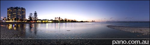
Gold Coast, Labrador
See this Virtual Tour in FullScreen High Definition mode with audio. QuickTime [1.6MB] Opens In New Window + Audio DevalVR [1.6MB] A couple of kilometres north of yesterdays Southport Virtual Tour is Labrador. Looking across the Broadwater you can see the trees of Wave Break Island, this leads to the Seaway where we were a couple of days ago. (Zoom out on the map below to see the area) Recent years have seen a flurry of development in Labrador, changing it’s status from a little rundown seaside suburb, into a hip place to live.
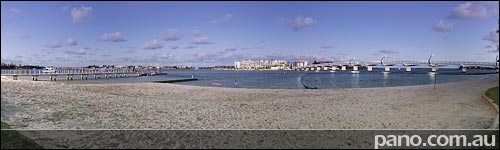
Gold Coast, Southport
See this Virtual Tour in FullScreen High Definition mode. QuickTime [1.6MB] Opens In New Window + Audio DevalVR [1.6MB] The Gold Coast doesn’t really have a CBD or ‘City’, but if it did, Southport would be it. We’re off the ocean beaches now, and onto the beaches of the Broadwater. Seaworld is across the water as well as Marina Mirage, (with the big sails) and the lights of Surfers Paradise.
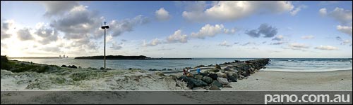
Gold Coast, Seaway
See this Virtual Tour in FullScreen High Definition mode. QuickTime [1.2MB] Opens In New Window + Audio DevalVR [1.2MB] The Gold Coast Seaway is the northernmost tip of the mainland beaches. Across the channel is South Stradbroke Island which extends a further 22km (13 miles) The seaway was built in 1986 to stablise what was a very dangerous bar, and incorporates the worlds 1st permanent sand bypass system. You can see pipes from the system on the pier in this virtual tour.
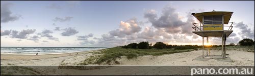
Gold Coast, Lifeguard Tower 45
See this Virtual Tour in FullScreen High Definition mode. QuickTime [1.2MB] Opens In New Window + Audio DevalVR [1.2MB] The Gold Coast runs Australia’s largest professional Lifeguard service employing 120+ staff & operating 46 towers. Tower 45 sits on the spit, very close to the northern end of the Gold Coast beaches, 35km (22 miles) from where we started at the Qld/NSW border. Surfers Paradise can be seen in the distance, as well as the sand bypass system pier, which pumps sand across the Gold Coast Seaway. We’ll check out the seaway tomorrow.
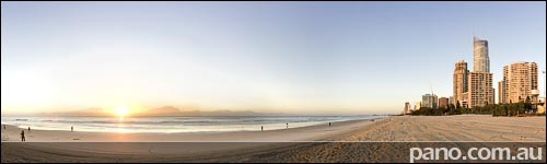
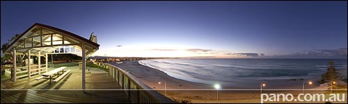
Gold Coast, Surfers Paradise Beach
See this Virtual Tour in FullScreen High Definition mode. QuickTime [1.8MB] Opens In New Window + Audio DevalVR [1.8MB] Surfers Paradise is at the heart of the Gold Coast, both geographically & for tourism. We’re on the beach outside the Cavill Mall which is the centre of Surfers Paradise. Check out the waves right now with some real time beachcam video here
Gold Coast, Point Danger
See this Virtual Tour in FullScreen High Definition mode. QuickTime [1.4MB] Opens In New Window + Audio DevalVR [1.4MB] Danger Point, overlooking Duranbah Beach, was named by Captain Cook in 1770 (Mr Cook was credited with discovering Australia). It was so named to warn later mariners of dangerous coral reefs off the coast. For his trouble the Captain Cook Memorial was built here 200 years later. You wouldn’t know to look at it, (I didn’t and I was there) but the memorial is in fact a lighthouse. The memorial lighthouse also marks the state border between the Gold Coast, Queensland & Tweed Heads, New South Wales. You can see a diagonal line under the monument, that is the border, which means this Gold Coast virtual tour, wasn’t shot on the Gold Coast 😉

Gold Coast, Rainbow Bay
Only a short distance from yesterdays Kirra Point Virtual Tour is Rainbow Beach & Snapper Rocks. From here it’s a short walk up the headland to Point Danger & the NSW border.
Gold Coast, Kirra Point
See this Virtual Tour in FullScreen High Definition mode. QuickTime [1.4MB] Opens In New Window + Audio DevalVR [1.4MB] The Gold Coast is beautiful beaches, fantastic year round weather, tropical rainforests, laid back lifestyle & 9x more water ways than Venice. (260kms (160miles) of navigable waterways) With a population of less than 500,000 it is a small city with all the facilities of a state capital, and more. In this Virtual Tour at Kirra Point we can see from the Qld/NSW border all the way to the lights of Surfers Paradise 20km (12 miles) away. Greenmount & Kirra beaches are on each side of the point.
Blue Mountains, Private View
See this Virtual Tour in FullScreen High Definition mode. QuickTime [1.8MB] Opens In New Window + Audio DevalVR [1.8MB] This amazing spot is down a long narrow ‘goat track’ with no signage or information at the obscured entrance. We’re in Leura across the road from the Toy Museum and only 1 ridge over from Echo Point where we visited a couple of days ago. This is our last Blue Mountains Virtual Tour for the time being. I didn’t have much shooting time in the mountains as I was attending a Bible College class reunion. I hope to get back to the Blue Mountains again this year to do a whole lot more panos for you Blue Mountains Reviews, Links, Websites – Click Here
Blue Mountains, Toy Museum
See this Virtual Tour in FullScreen High Definition mode. QuickTime [3.6MB] Opens In New Window DevalVR [3.6MB] Leuralla is a toy & rail museum in the Blue Moutains. It’s a lovely spot, just across the road from more stunning views of Jamison Valley, which we’ll see tomorrow. Check out their website, linked above, for a sample of what’s inside this magnificent property. I hope to shoot a lot more of this place next time I’m in the mountains. Blue Mountains Reviews, Links, Websites – Click Here
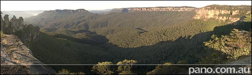
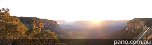
Blue Mountains, Jamison Valley
See this Virtual Tour in FullScreen High Definition mode. QuickTime [1.5MB ] Opens In New Window DevalVR [1.5MB ] Today we’ve moved a short distance from yesterdays post, but the view has changed dramatically. Instead of an info. board below us, now there is a cliff that drops 150m to Jamison Valley. Quite some time ago a little known scientist had this to say about the place, “Below is the grand bay or gulf, for I know not what other name to give it, thickly covered with forest. The point of view is situated as it were at the head of the Bay, for the line of cliff diverges away on each side, showing headland, behind headland, as on a bold Sea coast.” Charles Darwin. It doesn’t seem to have changed much in the last 170yrs. Blue Mountains Reviews, Links, Websites – Click Here
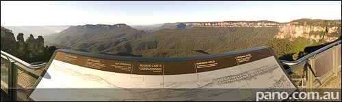
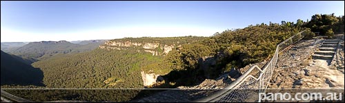
Blue Mountains, Echo Point
See this Virtual Tour in FullScreen High Definition mode. QuickTime [2.1MB ] Opens In New Window DevalVR [2.1MB ] Echo Point is one of the best known and most photographed landmarks in New South Wales. At 170m high Echo point is the tourist hub of the Blue Mountains and is visited by over 3 million people every year. The Point is located just outside the township of Katoomba, the capital of the Blue Mountains. In this virtual tour we’ve overlooking the Jamison Valley, I’ve shot right over the top of the info board so you can identify the landmarks, just as if you were there We’ll take a closer look at the valley tomorrow. Blue Mountains Reviews, Links, Websites – Click Here
Blue Mountains, Govetts Leap
See this Virtual Tour in FullScreen High Definition mode. QuickTime [2.3MB ] Opens In New Window DevalVR [2.3MB ] The Blue Mountains is a wonderful place 1.5hr drive west of Sydney. We’ll spend the next few days here having a look around. Govetts Leap, near Blackheath in the Blue Mountains, provides a spectacular point to view the Govetts and Grose gorges. The vertical cliffs drop 160 metres, with the floor of the gorge lying over 400 metres below the lookout. In 1846 Travel writer G.C. Mundy wrote of Govetts Leap:” It is Certainly one of the grandest freaks of nature I have seen in any country – quite beyond the power of pen or pencil to delineate” Blue Mountains Reviews, Links, Websites – Click Here
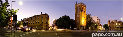
Hobart, Macquarie St
See this Virtual Tour in FullScreen High Definition mode. QuickTime [1.7MB ] Opens In New Window DevalVR [1.7MB ] This is Macquarie St, the main thoroughfare through Hobart City. Travelling all the way down the street will see you arrive at the Cenotaph of the War Memorial we looked at last week, while turning down Murray St, will take you to Salamanca Markets and the waterfront where we’ve spent a lot of time at this destination. St Davids Cathedral sits on opposite street corner. It was built between 1868 and 1936 taking 68yrs to complete the architects original vision. While across the road is the Tasmanian Treasury Building built in 1841, and used as a police station until 1858. I hope you’ve enjoyed a small look at Hobart, it’s a wonderful city. There is far more to see in and around Hobart, and we’ll be checking out some local places like Port Arther & Russell Falls later. I’ve had a request to look at the Blue Mountains west of Sydney next, so that’s where we’ll start tomorrow. Following the Blue Mountains we’ll be checking out some of my home town… The Gold Coast. Hobart Reviews, Links, Websites – Click Here
Hobart, Salamanca Square
See this Virtual Tour in FullScreen High Definition mode. QuickTime [1.6MB ] Opens In New Window DevalVR [1.6MB ] Behind Salamanca Place is Salamanca Square, where you can sit by the cooling fountain with a cup of coffee and a muffin and listen to a guitar or a flute player. You can even use ‘the facilities‘ if you need to go. I found them via our National Toilet Map See Full Size Google Map with all Hobart Virtual Tours – Click Here.INSERT_MAP Hobart Reviews, Links, Websites – Click Here
Hobart, Constitution Dock II
See this Virtual Tour in FullScreen High Definition mode. QuickTime [1.3MB ] Opens In New Window DevalVR [1.3MB ] We visited Constitution Dock last week, here is another view on the other side of the Dock looking back towards the city. See Full Size Google Map with all Hobart Virtual Tours – Click Here.INSERT_MAP Hobart Reviews, Links, Websites – Click Here
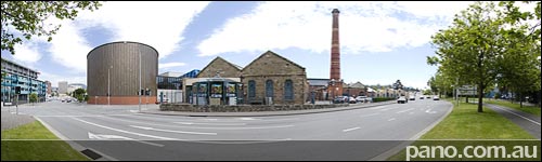
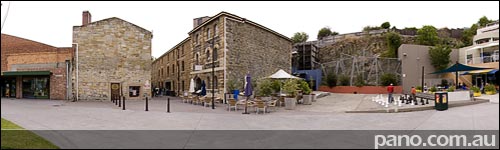
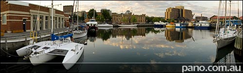
Hobart, Gas Works
See this Virtual Tour in FullScreen High Definition mode. QuickTime [2.8MB ] Opens In New Window DevalVR [2.8MB ] The Hobart Gasworks, pictured here, was first turned on in 1857. It produced gas made from British coal that brought the town’s street lamps to life & replaced a handful of whale-oil lamps. These days it’s a Rum distillery & Museum, restaurant & a couple of other shops. The huge water tank like structure across the road, is actually an 1100 seat concert hall & convention centre belonging to the, attached, Grand Chancellor Hotel. Hobart Reviews, Links, Websites – Click Here
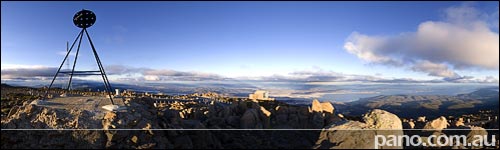
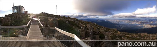
Hobart, Mountain Peak
See this Virtual Tour in FullScreen High Definition mode. QuickTime [1.5MB ] Opens In New Window DevalVR [1.5MB ] We started Hobart on Mt Wellington, and here is another virtual tour, this time from the peak. It allows you to see a lot more of the region around Hobart. The mountain peak is 1270m (4166ft) high, while the communications tower (the big white one) is 130m high. Hobart Reviews, Links, Websites – Click Here
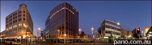
Hobart, City
See this Virtual Tour in FullScreen High Definition mode. QuickTime [1.3MB ] Opens In New Window DevalVR [1.3MB ] Here on the corner of Collins and Murray St we’re in the heart of the city cbd. Hobart is a quiet and peaceful city, it’s certainly safe to walk around anytime. With heaps of parks, waterfront & a lot of history, Hobart is a wonderful city to visit. (Or live) See Full Size Google Map with all Hobart Virtual Tours – Click Here.INSERT_MAP
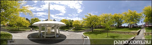
Hobart, Worlds Prettiest Roundabout
See this Virtual Tour in FullScreen High Definition mode. QuickTime [2.5MB] Opens In New Window DevalVR [2.5MB] While I’m sure there is a prettier round-a-bout somewhere in the world, this one is ‘pretty’ special. Oh and it’s not really a roundabout. When driving, it looks like one, sounds like one, tastes like one, but it has traffic lights so beware. I almost got into trouble a couple of times going around the ’roundabout’ only to slam on the breaks when I realised I had a red light. [Update] It was pointed out to me that some might think the fountain is the middle of a tiny roundabout. But in this Virtual Tour everything you can see is in the middle of a big roundabout. Have a look at the map below. The monument in this place is to the Mayors of Hobart from memory, again I can’t find any info about it. The water surges through the fountains up the pole for a while, then comes bucketing down the centre opening. You can also see the glass panels in the bottom of the dish, which allow you to see…. the water Hobart Reviews, Links, Websites – Click Here
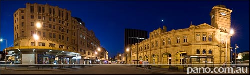
Hobart, Bus Mall
See this Virtual Tour in FullScreen High Definition mode. QuickTime [1.5MB] Opens In New Window DevalVR [1.5MB] Please forgive the rather lame title, but this beautiful street is the ‘Bus Mall’. With it’s ornate buildings & paved street it’s the prettiest bus mall I’ve ever seen. The mall is on Elizabeth St, just a couple of blocks from the Pier which we featured 4 days ago. The most impressive building in the street is the Post Office which features the Clock Tower. Built in 1905 at a the time when there was strong expenditure constraints imposed by the new Commonwealth Government, the clock and tower of the GPO were funded by the people of Hobart See Full Size Google Map with all Hobart Virtual Tours – Click Here.INSERT_MAP Hobart Reviews, Links, Websites – Click Here
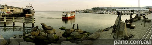
Hobart, Constitution Dock
See this Virtual Tour in FullScreen High Definition mode. QuickTime [1.6MB] Opens In New Window DevalVR [1.6MB] Constitution Dock is surrounded by some of the biggest tourist attractions in Hobart and is home to the finish line of the Sydney to Hobart Yacht race, the nearby area is noted for its tantalising cafes and restaurants. Also in this area is Sullivan’s cove which features specialty shops, restaurants and a whisky distillery. The area is on the water and walking along the water front taking in all the historical surroundings, makes for a very pleasant day. I’m also looking for information about the interesting sculptures in the foreground of this pano ’cause I didn’t have time to stop and smell the (proverbial) roses on this shoot. When I find the info, I’ll update this post. Hobart Reviews, Links, Websites – Click Here
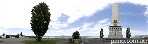
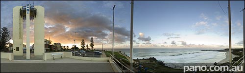
Hobart, War Memorial
See this Virtual Tour in FullScreen High Definition mode. QuickTime [1.7MB] Opens In New Window DevalVR [1.7MB] The Hobart War Memorial (Cenotaph) was unveiled in 1925 and initially commemorated those Tasmanians who served in the Great War. The site of the Cenotaph was selected for its prominence both to the city and the River Derwent. It is axially aligned with Macquarie Street, the city’s major civic thoroughfare. From the Cenotaph there are commanding views of the city, Mount Wellington and the Derwent Estuary. In this pano we can see the Derwent River & the Tasman Bridge, across Hobart City surrounding suburbs. Unfortunately our view of Mt Wellington (where we started the Hobart Destination) is obscured by a rather large tree. Hobart Reviews, Links, Websites – Click Here
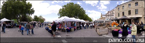
Hobart, Salamanca Markets
See this Virtual Tour in FullScreen High Definition mode. QuickTime [1.9MB] Opens In New Window DevalVR [1.9MB] Salamanca Markets began in 1972 with just 10 stalls. Today it is almost a state institution, and a must visit for anyone visiting Tasmania. The Markets operate every Saturday from 8.30am to 3pm, rain, hail or shine. Salamanca Place itself consists of rows of sandstone buildings, formerly warehouses for the port of Hobart Town that have since been converted into restaurants, galleries, craft shops and offices. It was named after the victory in 1812 of the Duke of Wellington in the Battle of Salamanca in the Spanish province of Salamanca. This panorama was shot late in the day, just before closing time, so all the stalls are looking a bit empty. Earlier in the day this place is really packed and buzzing, but getting good Virtual Tours at that time would be almost impossible. See Full Size Google Map with all Hobart Virtual Tours – Click Here.INSERT_MAP Hobart Reviews, Links, Websites – Click Here
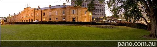
Hobart, Parliament House
See this Virtual Tour in FullScreen High Definition mode. QuickTime [2.4MB] Opens In New Window DevalVR [2.4MB] Tasmania’s Parliament House was designed in 1830 as the Customs House. It was completed in 1840 and soon became home to the Tasmanian Parliament. The House looks over Parliament Square park, and across the road to the water. The House is bordered by Salamanca Place where the famous ‘Salamanca Markets’ run each Saturday. Being a foreigner (not from Tasmania) I didn’t realise this was the most important government building in Tassie, so was walking around taking pictures on the property before being asked by security to move on. I was told I could shoot from the park as it is public property. This was a fortunate incident, as I wouldn’t have this beautiful virtual tour otherwise. See Full Size Google Map with all Hobart Virtual Tours – Click Here.INSERT_MAP Hobart Reviews, Links, Websites – Click Here
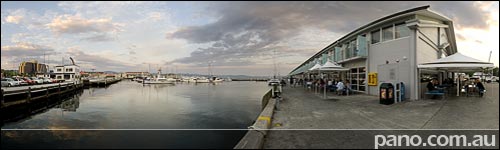
Hobart, Elizabeth St Pier
See this Virtual Tour in FullScreen High Definition mode. QuickTime [1.3MB] Opens In New Window DevalVR [1.3MB] Elizabeth is one of the main streets in Hobart. Running from NewTown in the north, as the street travels south, it encompasses the Elizabeth St Mall, Hobart Bus Mall, Elizabeth College and terminates here at the Pier. Elizabeth Street Pier was first constructed in 1866 to provide steamship accommodation. Between 1931 and 1934, the original pier was demolished and the new pier was built with the addition of a rail connection. The latest redevelopment project, completed in the late ’90s, was to maintain the presence of the existing shed form and maintain maritime usage and full public access around the perimeter, while converting the building to a new use, which included the housing of serviced apartments and restaurants. Some years ago I shot virtual tours of the serviced apartments (then called Oakford) here on the Pier. I won’t show them here though, as they were done with old technology & not available in FullScreen resolution. See Full Size Google Map with all Hobart Virtual Tours – Click Here.INSERT_MAP Hobart Reviews, Links, Websites – Click Here
Hobart, View From The Top
See this Virtual Tour in FullScreen High Definition mode. QuickTime [1.6MB] Opens In New Window DevalVR [1.6MB] Hobart is the capital city of Tasmania, a gorgeous island state 350 km (220 miles) off the south east coast of Australia. Compared to most Australian States Tasmania is tiny. Sydney to Broken Hill which I did for the previous destination takes about 14hrs to drive, and yet both cities are in the same state (New South Wales – NSW). In the same time I think I could have driven through every major town in Tasmania while circumnavigating the state. Of course size is relative, Tasmania won’t be so small to Europeans seeing that it’s about twice the size of Holland. Even though it’s a ‘relatively’ small island, there is so much diversity, so much to see, and we’ll be seeing some of it, over the coming months. Where possible, I like to show an overview of a place on the first day, so here is Hobart from the top of Mt Wellington. In this pano we’re at a height of 1261m (4136ft) and as you can see not far from Hobart City. If you’re interested in other places in Tasmania we’ll be covering Stanley, Smithon, Burnie, Arthur River, Devonport, Deloraine, Sheffield, Cradle Mountain, Strahan, Queenstown, Ross, Launceston, Bridport, Scottsdate, Bicheno, St Marys, Swansea & Port Arthur over the coming months. See Full Size Google Map with all Hobart Virtual Tours – Click Here.INSERT_MAP Hobart Reviews, Links, Websites – Click Here
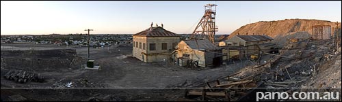
Broken Hill, Past & Future
See this Virtual Tour in FullScreen High Definition mode. QuickTime [1.6MB] Opens In New Window DevalVR [1.6MB] As the sun sets on mining in Broken Hill and tourism takes it’s place as the towns life blood, I thought it fitting to show where it all began & where it’s going in this one pano. This is the site of the first mine at Broken Hill, started back in 1885, it’s now a major tourist attraction with Mine Tours. In the background the beautiful town of Broken Hill stretches out in this desolate place and we move on to another town. If you ever have the opportunity to visit here, I encourage you to take it, you won’t be dissappointed.
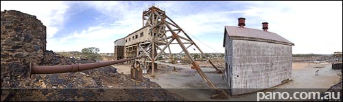
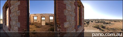
Broken Hill, All That’s Left
See this Virtual Tour in FullScreen High Definition mode. QuickTime [1.9MB] Opens In New Window DevalVR [1.9MB] This is Junction Mine, first pegged in 1884, it sits on the northern end of the original broken hill. The jagged black outcrop we’re standing on is the weathered surface expression or ‘gossan’ of the Broken Hill orebody. At the time of discovery, the gossan cropped out over a length of 2.5 km (1.5 miles) and formed the capping of the broken hill, which gave no hint of the fabulous wealth below. The gossan contained a small amount of metal ore, but when the miners got to 30m (90ft) below the surface, rich silver deposits were found. In fact the worlds largest silver-lead-zinc deposit ever found, and billions of dollars worth of ore have since been extracted. (In todays $) This spot is basically all that’s left of the original broken hill. See Full Size Google Map with all Broken Hill Virtual Tours – Click Here.INSERT_MAP Broken Hill Reviews, Links, Websites – Click Here
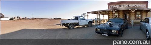
Broken Hill, Silverton Hotel
See this Virtual Tour in FullScreen High Definition mode. QuickTime [1.1MB] Opens In New Window DevalVR [1.1MB] Since Mad Max 2 was filmed around Silverton it is fitting the Silverton Hotel has a replica Ford Interceptor (Like Mel drives in the movie) sitting out front. The hotel began life in 1885 as the towns post office, and today contains a photographic collection bearing witness to the films shot in the region. See Full Size Google Map with all Silverton Virtual Tours – Click Here.INSERT_MAP Broken Hill/Silverton Reviews, Links, Websites – Click Here
Broken Hill, Silverton Galleries
See this Virtual Tour in FullScreen High Definition mode. QuickTime [1.8MB] Opens In New Window DevalVR [1.8MB] There are a number of Art Galleries in Silverton these days. The one shown here belongs to Peter Browne. In this pano you can also see the old Church, and the buildings in the distance which are on the main road through Silverton. On that road you’ll also find the Horizon Gallery.
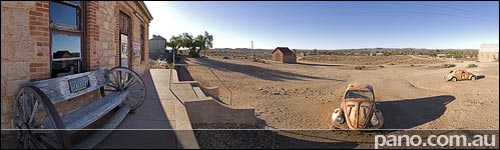
Broken Hill, Silverton Ruins
See this Virtual Tour in FullScreen High Definition mode. QuickTime [1.9MB] Opens In New Window DevalVR [1.9MB] Silverton is a relative ghost town about 20mins drive north east of Broken Hill. After starting the resource boom of the region in 1883, and growing to a peak population of 3000 the town was virtually abandoned by 1899 with the discovery and population build up nearby Broken Hill. In fact much of the town was deconstructed and transported to Broken Hill because of severe shortage of building materials at the time. This is the reason so few buildings remain. Today Silverton is a tourist town, with a popluation of 60 and about 20 surviving structures. It is also the scene of many movies including Mad Max II (Road warrior) & Dirty Deeds. We’ll hang around here for a day or two, before ending up back in Broken Hill.
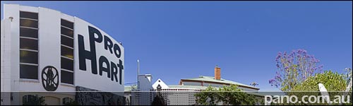
Broken Hill, Pro Hart Gallery
See this Virtual Tour in FullScreen High Definition mode. QuickTime [1.5MB] Opens In New Window DevalVR [1.5MB] The Pro Hart gallery resides in the northern part of Broken Hill, in a quiet residential neighbourhood. You should view the FullScreen pano of the gallery (if you have broadband) as there are many sculptures & artifacts to see outside the gallery. Unfortunately I can’t show you 3 storey interior, as pictures are not allowed. [As is the custom with most galleries] There are also 3-4 Rolls Royce cars on the property, 1 of them painted from top to bottom in Pro’s outback scenes, and many other artists work in the gallery. In the map below, if you look across the road and to the left about 3 properties, you’ll see what appears to be an empty lot. This is part of Pro’s gallery also containing numerous large sculptures. See Full Size Google Map with all Broken Hill Virtual Tours – Click Here.INSERT_MAP Broken Hill Reviews, Links, Websites – Click Here
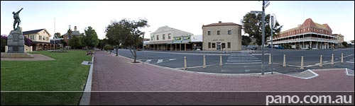
Broken Hill, Town Landmarks
See this Virtual Tour in FullScreen High Definition mode. QuickTime [1.2MB] Opens In New Window DevalVR [1.2MB] The Palace Hotel made famous in the movie Priscilla, Queen of the Desert sits on the opposite corner for this virtual tour. With it’s 3 storeys, lengthy verandahs and elaborate cast-iron balustrades it is the most impressive hotel in town. Back on this side of the street is the War Memorial, followed by the Courthouse built in 1889 & the Federation style Technical College / Museum built in 1900. See Full Size Google Map with all Broken Hill Virtual Tours – Click Here.INSERT_MAP Broken Hill Reviews, Links, Websites – Click Here
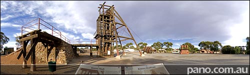
Broken Hill, Mining History In Town
See this Virtual Tour in FullScreen High Definition mode. QuickTime [1.9MB] Opens In New Window DevalVR [1.9MB] Directly across the road from the visitors centre is a park with some interesting history on display. Firstly back in 1984, the town spent a ton of time (and no doubt money) moving the decommissioned Kintore Headframe from the Central Mine to the park. Before and after photos can be viewed by looking at the information boards in the fullscreen virtual tour. I won’t go into the details here, as you can read it all in the big virtual tour, just zoom in on the boards. There are also other mining artifacts spread around the park. This park also contains a couple of very large Pro Hart sculptures. For those not in the know, Pro Hart was an Australian artist famous for his depictions of the outback and life in it. He was born, bred, lived and died in Broken Hill. We’ll be visiting his gallery (outside only) soon. See Full Size Google Map with all Broken Hill Virtual Tours – Click Here.INSERT_MAP Broken Hill Reviews, Links, Websites – Click Here
Broken Hill, Yesterday & Today
See this Virtual Tour in FullScreen High Definition mode. QuickTime [2.6MB] Opens In New Window DevalVR [2.6MB] In todays post you really need to view the FullScreen virtual tour [Link Above] to appreciate the included historical images. This pano is shot from a hill in the middle of the town, looking south east to the huge hill of dirt we’ve been on for the past couple of days. On the ‘Broken Earth’, you can see the Restaurant & the Miners Memorial, and also appreciate how it towers over the town. The historical photo boards in the park depict the view from here. The main panorama was shot in 1907, and shows that the original ‘Broken Hill’ was basically gone by then, while the town had become quite large. The smaller image below the panorama & right in front of us was shot in 1888 almost 20 years earlier & shows the jagged outline of the original hill. See Full Size Google Map with all Broken Hill Virtual Tours – Click Here.INSERT_MAP Broken Hill Reviews, Links, Websites – Click Here

Broken Hill, Miners Memorial
The Miners Memorial sits atop the ‘line of load’ (the big hill of dirt where THE broken hill used to be) along side the Broken Earth Cafe Restaurant. It’s a memorial to the 700+ miners who have died here since the 1800’s when the mines began. The name and cause of death for every fatality is listed in the memorial. The 2 structures were funded by a ‘Centenery of Federation’ grant, & were completed in 2000. And as mentioned in previous posts, you get a great view of northern Broken Hill from up here.
Subscribe to Panedia News
We promise only send you beautiful, high resolution, panoramic photography posts for your enjoyment…
![]()