by Aaron Spence | Feb 10, 2007 | Panoramas
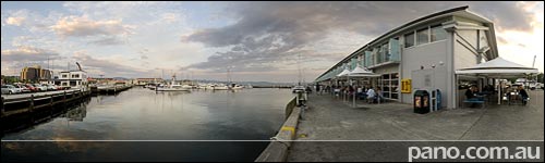
See this Virtual Tour in FullScreen High Definition mode. QuickTime [1.3MB] Opens In New Window DevalVR [1.3MB] Elizabeth is one of the main streets in Hobart. Running from NewTown in the north, as the street travels south, it encompasses the Elizabeth St Mall, Hobart Bus Mall, Elizabeth College and terminates here at the Pier. Elizabeth Street Pier was first constructed in 1866 to provide steamship accommodation. Between 1931 and 1934, the original pier was demolished and the new pier was built with the addition of a rail connection. The latest redevelopment project, completed in the late ’90s, was to maintain the presence of the existing shed form and maintain maritime usage and full public access around the perimeter, while converting the building to a new use, which included the housing of serviced apartments and restaurants. Some years ago I shot virtual tours of the serviced apartments (then called Oakford) here on the Pier. I won’t show them here though, as they were done with old technology & not available in FullScreen resolution. See Full Size Google Map with all Hobart Virtual Tours – Click Here.INSERT_MAP Hobart Reviews, Links, Websites – Click...
by Aaron Spence | Feb 9, 2007 | Panoramas
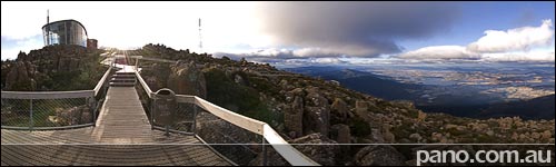
See this Virtual Tour in FullScreen High Definition mode. QuickTime [1.6MB] Opens In New Window DevalVR [1.6MB] Hobart is the capital city of Tasmania, a gorgeous island state 350 km (220 miles) off the south east coast of Australia. Compared to most Australian States Tasmania is tiny. Sydney to Broken Hill which I did for the previous destination takes about 14hrs to drive, and yet both cities are in the same state (New South Wales – NSW). In the same time I think I could have driven through every major town in Tasmania while circumnavigating the state. Of course size is relative, Tasmania won’t be so small to Europeans seeing that it’s about twice the size of Holland. Even though it’s a ‘relatively’ small island, there is so much diversity, so much to see, and we’ll be seeing some of it, over the coming months. Where possible, I like to show an overview of a place on the first day, so here is Hobart from the top of Mt Wellington. In this pano we’re at a height of 1261m (4136ft) and as you can see not far from Hobart City. If you’re interested in other places in Tasmania we’ll be covering Stanley, Smithon, Burnie, Arthur River, Devonport, Deloraine, Sheffield, Cradle Mountain, Strahan, Queenstown, Ross, Launceston, Bridport, Scottsdate, Bicheno, St Marys, Swansea & Port Arthur over the coming months. See Full Size Google Map with all Hobart Virtual Tours – Click Here.INSERT_MAP Hobart Reviews, Links, Websites – Click...
by Aaron Spence | Feb 8, 2007 | Panoramas
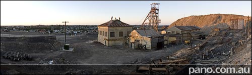
See this Virtual Tour in FullScreen High Definition mode. QuickTime [1.6MB] Opens In New Window DevalVR [1.6MB] As the sun sets on mining in Broken Hill and tourism takes it’s place as the towns life blood, I thought it fitting to show where it all began & where it’s going in this one pano. This is the site of the first mine at Broken Hill, started back in 1885, it’s now a major tourist attraction with Mine Tours. In the background the beautiful town of Broken Hill stretches out in this desolate place and we move on to another town. If you ever have the opportunity to visit here, I encourage you to take it, you won’t be...
by Aaron Spence | Feb 7, 2007 | Panoramas
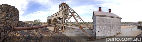
See this Virtual Tour in FullScreen High Definition mode. QuickTime [1.9MB] Opens In New Window DevalVR [1.9MB] This is Junction Mine, first pegged in 1884, it sits on the northern end of the original broken hill. The jagged black outcrop we’re standing on is the weathered surface expression or ‘gossan’ of the Broken Hill orebody. At the time of discovery, the gossan cropped out over a length of 2.5 km (1.5 miles) and formed the capping of the broken hill, which gave no hint of the fabulous wealth below. The gossan contained a small amount of metal ore, but when the miners got to 30m (90ft) below the surface, rich silver deposits were found. In fact the worlds largest silver-lead-zinc deposit ever found, and billions of dollars worth of ore have since been extracted. (In todays $) This spot is basically all that’s left of the original broken hill. See Full Size Google Map with all Broken Hill Virtual Tours – Click Here.INSERT_MAP Broken Hill Reviews, Links, Websites – Click...
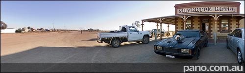
by Aaron Spence | Feb 6, 2007 | Panoramas
See this Virtual Tour in FullScreen High Definition mode. QuickTime [1.1MB] Opens In New Window DevalVR [1.1MB] Since Mad Max 2 was filmed around Silverton it is fitting the Silverton Hotel has a replica Ford Interceptor (Like Mel drives in the movie) sitting out front. The hotel began life in 1885 as the towns post office, and today contains a photographic collection bearing witness to the films shot in the region. See Full Size Google Map with all Silverton Virtual Tours – Click Here.INSERT_MAP Broken Hill/Silverton Reviews, Links, Websites – Click...
by Aaron Spence | Feb 5, 2007 | Panoramas
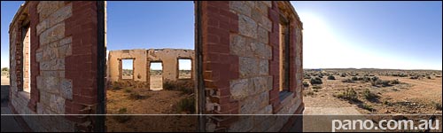
See this Virtual Tour in FullScreen High Definition mode. QuickTime [1.8MB] Opens In New Window DevalVR [1.8MB] There are a number of Art Galleries in Silverton these days. The one shown here belongs to Peter Browne. In this pano you can also see the old Church, and the buildings in the distance which are on the main road through Silverton. On that road you’ll also find the Horizon...
by Aaron Spence | Feb 4, 2007 | Panoramas
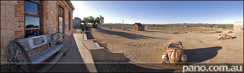
See this Virtual Tour in FullScreen High Definition mode. QuickTime [1.9MB] Opens In New Window DevalVR [1.9MB] Silverton is a relative ghost town about 20mins drive north east of Broken Hill. After starting the resource boom of the region in 1883, and growing to a peak population of 3000 the town was virtually abandoned by 1899 with the discovery and population build up nearby Broken Hill. In fact much of the town was deconstructed and transported to Broken Hill because of severe shortage of building materials at the time. This is the reason so few buildings remain. Today Silverton is a tourist town, with a popluation of 60 and about 20 surviving structures. It is also the scene of many movies including Mad Max II (Road warrior) & Dirty Deeds. We’ll hang around here for a day or two, before ending up back in Broken...

by Aaron Spence | Feb 3, 2007 | Panoramas
See this Virtual Tour in FullScreen High Definition mode. QuickTime [1.5MB] Opens In New Window DevalVR [1.5MB] The Pro Hart gallery resides in the northern part of Broken Hill, in a quiet residential neighbourhood. You should view the FullScreen pano of the gallery (if you have broadband) as there are many sculptures & artifacts to see outside the gallery. Unfortunately I can’t show you 3 storey interior, as pictures are not allowed. [As is the custom with most galleries] There are also 3-4 Rolls Royce cars on the property, 1 of them painted from top to bottom in Pro’s outback scenes, and many other artists work in the gallery. In the map below, if you look across the road and to the left about 3 properties, you’ll see what appears to be an empty lot. This is part of Pro’s gallery also containing numerous large sculptures. See Full Size Google Map with all Broken Hill Virtual Tours – Click Here.INSERT_MAP Broken Hill Reviews, Links, Websites – Click...
by Aaron Spence | Feb 2, 2007 | Panoramas
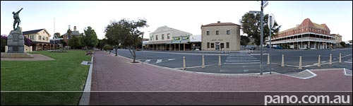
See this Virtual Tour in FullScreen High Definition mode. QuickTime [1.2MB] Opens In New Window DevalVR [1.2MB] The Palace Hotel made famous in the movie Priscilla, Queen of the Desert sits on the opposite corner for this virtual tour. With it’s 3 storeys, lengthy verandahs and elaborate cast-iron balustrades it is the most impressive hotel in town. Back on this side of the street is the War Memorial, followed by the Courthouse built in 1889 & the Federation style Technical College / Museum built in 1900. See Full Size Google Map with all Broken Hill Virtual Tours – Click Here.INSERT_MAP Broken Hill Reviews, Links, Websites – Click...
by Aaron Spence | Feb 1, 2007 | Panoramas
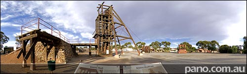
See this Virtual Tour in FullScreen High Definition mode. QuickTime [1.9MB] Opens In New Window DevalVR [1.9MB] Directly across the road from the visitors centre is a park with some interesting history on display. Firstly back in 1984, the town spent a ton of time (and no doubt money) moving the decommissioned Kintore Headframe from the Central Mine to the park. Before and after photos can be viewed by looking at the information boards in the fullscreen virtual tour. I won’t go into the details here, as you can read it all in the big virtual tour, just zoom in on the boards. There are also other mining artifacts spread around the park. This park also contains a couple of very large Pro Hart sculptures. For those not in the know, Pro Hart was an Australian artist famous for his depictions of the outback and life in it. He was born, bred, lived and died in Broken Hill. We’ll be visiting his gallery (outside only) soon. See Full Size Google Map with all Broken Hill Virtual Tours – Click Here.INSERT_MAP Broken Hill Reviews, Links, Websites – Click...
by Aaron Spence | Jan 31, 2007 | Panoramas
See this Virtual Tour in FullScreen High Definition mode. QuickTime [2.6MB] Opens In New Window DevalVR [2.6MB] In todays post you really need to view the FullScreen virtual tour [Link Above] to appreciate the included historical images. This pano is shot from a hill in the middle of the town, looking south east to the huge hill of dirt we’ve been on for the past couple of days. On the ‘Broken Earth’, you can see the Restaurant & the Miners Memorial, and also appreciate how it towers over the town. The historical photo boards in the park depict the view from here. The main panorama was shot in 1907, and shows that the original ‘Broken Hill’ was basically gone by then, while the town had become quite large. The smaller image below the panorama & right in front of us was shot in 1888 almost 20 years earlier & shows the jagged outline of the original hill. See Full Size Google Map with all Broken Hill Virtual Tours – Click Here.INSERT_MAP Broken Hill Reviews, Links, Websites – Click...

by Aaron Spence | Jan 30, 2007 | Panoramas
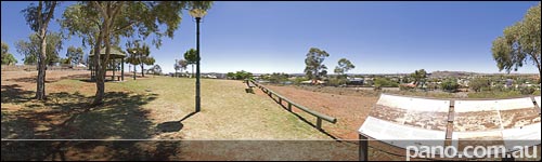
The Miners Memorial sits atop the ‘line of load’ (the big hill of dirt where THE broken hill used to be) along side the Broken Earth Cafe Restaurant. It’s a memorial to the 700+ miners who have died here since the 1800’s when the mines began. The name and cause of death for every fatality is listed in the memorial. The 2 structures were funded by a ‘Centenery of Federation’ grant, & were completed in 2000. And as mentioned in previous posts, you get a great view of northern Broken Hill from up...

by Aaron Spence | Jan 29, 2007 | Panoramas
Being a 120yr old mining town you’d expect to see many relics of the old mines, and there are, but not as many as you’d think. The vast mines & above ground operations of yesteryear were often broken down and replaced when new technology came along or when mines were abandoned. There are of course photos of the old operations, but not so many relics. Behind the original Broken Hill mine (Which is now a tour operation) I found this abandoned old car. It appears someone has tried to drive it in here in a wet period (of which Broken Hill has very few) and got it bogged. They’ve used planks to keep it out of the mud, but the back wheels have slid off, and the car has never moved again. Judging by the age of the car I would have thought this happened a very long time ago, but on the back of the vehicle are plastic water (or chemical) containers leading me to believe this car was not abandoned too long ago. In fact, just reading over this post I’ve postulated a theory. It was wet (which is rare), there is an old car with water tanks on the back, and a huge black water tank about 20 metres away. Perhaps someone was attempting to fill the portable water tanks from the black water tank which was overflowing in a rare wet period? If anyone can tell me what sort of car this is, or even when it was abandoned, I’ll update the post to keep everyone...

by Aaron Spence | Jan 28, 2007 | Panoramas
Broken Hill was founded on the ‘Line of Load’ a massive ore body that runs through the middle of ‘Broken Hill’. The original Hill is now gone, but for a few tiny remnants, and in its place lies a vast hill of excavated earth. This hill is said to be about the size of the original ‘Broken Hill’. Atop the vast hill is the Broken Earth Cafe & Restaurant which affords views over all the town. You can even see out to the Hill of Sculptures 6km’s away, mentioned a couple of days ago. Don’t let a map view of the area put you off. It looks like a big mine excavation site (and it is) but from the top you can see for miles, and have a meal at the same...

by Aaron Spence | Jan 27, 2007 | Panoramas
Broken Hill is a small town on the Edge of the Australian Outback. 1200km (745 miles) west of Sydney & 500km (310 miles) north east of Adelaide, it’s a very, very long way from anywhere. Broken Hill is also known as the ‘Silver City’ because of the vast amounts of silver extracted from the mines over the past 120 years, and being a mining town, many of it’s road are named after chemicals. In fact the road we’re standing on in the pano above is ‘Chloride St’, with Sulphide, Bromide & Oxide Streets running parallel to the main...

by Aaron Spence | Jan 26, 2007 | Panoramas
At 5.43 am on the 30th of October 2006, I was standing in the silent wonder of the outback, on a hill 1200km west of Sydney, 400m/1300ft high & 6km out from the small town of Broken Hill. [pop. 21,000] Atop this hill lies the Broken Hill Sculpture Symposium, started on April Fools Day 1993, and finished in May of the same year. There are 12 pieces in the exhibit, with Bajo el Sol Jaguar (Under the Jaguar Sun) being the most striking (IMHO), and the one I’ve chosen to highlight in this pano. In order to get to the Sculptures you can either drive to a carpark / picnic area, followed by a 20min walk or get a key from (and pay a fee to) the Tourist Info centre so you can pass through 2 gates that allow you to drive to the top. Either way, it’s well worth...

by Sandra Mexa | Jan 29, 0205 | Panoramas
Toowoomba ‘The Garden City’, is a south-east Queensland city famous for its annual Carnival of Flowers, held in Spring. But Autumn is when it really shines in its full splendor. Situated on the edge of the Great Dividing Range, 700 metres above sea level and with lower Autumn and Winter temperatures than the surrounding area, Toowoomba benefits from a quite unique climate. All over the city there is a significant number of deciduous trees from around the world, giving a singular display of autumn yellow, orange and red among the green foliage. Being there at this season is a privilege and watching sunrise at Picnic Point, just on the edge of the Great Dividing Range, is as much astonishing as...